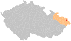
Havířov (administrative district)
Appearance
Administrative district of the municipality with extended powers of Havířov
Správní obvod obce s rozšířenou působností Havířov | |
|---|---|
 Location in the Moravian-Silesian Region within the Czech Republic | |
| Coordinates: 49°46′N 18°29′E / 49.767°N 18.483°E | |
| Country | |
| Region | Moravian-Silesian |
| District | Karviná |
| Municipality with extended powers | Havířov |
| Area | |
• Total | 88.19 km2 (34.05 sq mi) |
| Population (2024)[1] | |
• Total | 85,310 |
| • Density | 970/km2 (2,500/sq mi) |
| Time zone | UTC+1 (CET) |
| • Summer (DST) | UTC+2 (CEST) |
| Municipalities | 5 |
| * Cities and towns | 1 |
| * Market towns | 0 |
The administrative district of the municipality with extended powers of Havířov (abbreviated AD MEP Havířov; Czech: Správní obvod obce s rozšířenou působností Havířov, SO ORP Havířov) is an administrative district of municipality with extended powers in Karviná District in the Moravian-Silesian Region of the Czech Republic. It has existed since 1 January 2003, when the districts were replaced administratively. It includes 5 municipalities which have a combined population of about 85,000.
Municipalities
[edit]Cities and towns are in bold.
| Municipality | Population[1] | Area (km2) | Density |
|---|---|---|---|
| Albrechtice | 3,818 | 12.69 | 300 |
| Havířov | 69,694 | 32.08 | 2,172 |
| Horní Bludovice | 2,591 | 8.98 | 288 |
| Horní Suchá | 4,366 | 9.80 | 445 |
| Těrlicko | 4,841 | 24.65 | 196 |
Demographics
[edit]
|
|
| ||||||||||||||||||||||||||||||||||||||||||||||||||||||
| Source: Censuses[2][3] | ||||||||||||||||||||||||||||||||||||||||||||||||||||||||
References
[edit]- ^ a b "Population of administrative districts of municipalities with extended powers of the Czech Republic, 1 January 2024" (PDF). Czech Statistical Office. 17 May 2024.
- ^ "Historický lexikon obcí České republiky 1869–2011" (in Czech). Czech Statistical Office. 2015-12-21.
- ^ "Population Census 2021: Population by sex". Public Database. Czech Statistical Office. 2021-03-27.
