Gia Viễn district
Appearance
You can help expand this article with text translated from the corresponding article in Vietnamese. (March 2009) Click [show] for important translation instructions.
|
Gia Viễn district
Huyện Gia Viễn | |
|---|---|
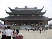
 Path leading to Bái Đính temple | |
 | |
| Country | |
| Region | Red River Delta |
| Province | Ninh Bình |
| Capital | Me |
| Area | |
• Total | 68 sq mi (176 km2) |
| Population (2008) | |
• Total | 119,284 |
| Time zone | UTC+7 (Indochina Time) |
Gia Viễn is a rural district of Ninh Bình province in the Red River Delta region of Vietnam. As of 2008 the district had a population of 119,284.[1] The district covers an area of 176 km2. The district capital lies at Me.[1]
Photos of Gia Viễn
[edit]References
[edit]- ^ a b "Districts of Vietnam". Statoids. Retrieved March 20, 2009.
External links
[edit]Wikimedia Commons has media related to Gia Vien District.


