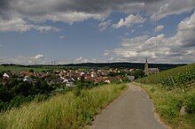
Genheim
Appearance
Genheim | |
|---|---|
| Coordinates: 49°56′22″N 7°48′59″E / 49.939444°N 7.816389°E | |
| Country | Germany |
| State | Rhineland-Palatinate |
| District | Mainz-Bingen |
| Municipal assoc. | Rhein-Nahe |
| Municipality | Waldalgesheim |
| Area | |
• Total | 6.01 km2 (2.32 sq mi) |
| Elevation | 243 m (797 ft) |
| Population | |
• Total | 525 |
| • Density | 87/km2 (230/sq mi) |
| Time zone | UTC+01:00 (CET) |
| • Summer (DST) | UTC+02:00 (CEST) |
| Postal codes | 55425 |
| Dialling codes | 06724 |
Genheim is a village and an Ortsteil (subdivision) of the municipality Waldalgesheim in the district Mainz-Bingen in Rhineland-Palatinate, Germany. The village is managed by the collective municipality of Rhein-Nahe, which has its administrative office in Bingen am Rhein.

Geography
[edit]Location
[edit]Genheim is located on the southeast edge of the Hunsrück between Koblenz and Bad Kreuznach, south of the Bingen Forest (Binger Wald) and the west of the river Nahe, some 6 km west of Bingen.
Neighbouring villages
[edit]Genheim's neighbours are Waldalgesheim, Waldlaubersheim, Roth and Schweppenhausen.
History
[edit]The first documented mention in the Lorsch codex was in 767 A.D. Formerly an independent municipality, it is part of the municipality Waldalgesheim since 1970.
References
[edit]


