Gandoman
Appearance
Gandoman
Persian: گندمان | |
|---|---|
City | |
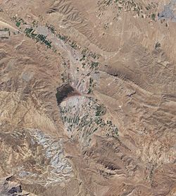
 Gandoman is in the center of this satellite image | |
| Coordinates: 31°51′53″N 51°09′16″E / 31.86472°N 51.15444°E[1] | |
| Country | Iran |
| Province | Chaharmahal and Bakhtiari |
| County | Borujen |
| District | Gandoman |
| Population (2016)[2] | |
• Total | 6,291 |
| Time zone | UTC+3:30 (IRST) |
Gandoman (Persian: گندمان)[a] is a city in and capital of Gandoman District, in Borujen County, Chaharmahal and Bakhtiari province, Iran.[4] It also serves as the administrative center for Gandoman Rural District.[5]
Demographics
[edit]Ethnicity
[edit]The city is populated by Lurs.[6]
Population
[edit]At the time of the 2006 National Census, the city's population was 5,578 in 1,388 households.[7] The following census in 2011 counted 5,761 people in 1,576 households.[8] The 2016 census measured the population of the city as 6,291 people in 1,852 households.[2]
See also
[edit]Notes
[edit]References
[edit]- ^ OpenStreetMap contributors (28 August 2024). "Gandoman, Borujen County" (Map). openstreetmap.org (OpenStreetMap) (in Persian). Retrieved 28 August 2024.
- ^ a b Census of the Islamic Republic of Iran, 1395 (2016): Chaharmahal and Bakhtiari Province. amar.org.ir (Report) (in Persian). The Statistical Center of Iran. Archived from the original (Excel) on 24 May 2019. Retrieved 19 December 2022.
- ^ Gandoman can be found at GEOnet Names Server, at this link, by opening the Advanced Search box, entering "-3063398" in the "Unique Feature Id" form, and clicking on "Search Database".
- ^ Habibi, Hassan (30 September 2015) [Approved 21 June 1369]. Approval of the organization and chain of citizenship of the elements and units of the national divisions of Chaharmahal and Bakhtiari province, centered in the city of Shahrekord. rc.majlis.ir (Report) (in Persian). Ministry of the Interior, Defense Political Commission of the Government Board. Notification 82826/T124K. Archived from the original on 21 September 2016. Retrieved 2 December 2023.
- ^ Moussavi, Mirhossein (c. 2014) [Approved 2 February 1366]. Creation and formation of seven rural districts including villages, farms and places located in Borujen County under Chaharmahal and Bakhtiari province. rc.majlis.ir (Report) (in Persian). Ministry of the Interior, Council of Ministers. Proposal 53.4.8490. Archived from the original on 9 January 2014. Retrieved 3 April 2024 – via Research Center of the System of Laws of the Islamic Council of Farabi Library of Mobile Users.
- ^ "Language distribution: Chahar Mahal va Bakhtiari Province". Iran Atlas. Retrieved 25 March 2021.
- ^ Census of the Islamic Republic of Iran, 1385 (2006): Chaharmahal and Bakhtiari Province. amar.org.ir (Report) (in Persian). The Statistical Center of Iran. Archived from the original (Excel) on 20 September 2011. Retrieved 25 September 2022.
- ^ Census of the Islamic Republic of Iran, 1390 (2011): Chaharmahal and Bakhtiari Province. irandataportal.syr.edu (Report) (in Persian). The Statistical Center of Iran. Archived from the original (Excel) on 16 January 2023. Retrieved 19 December 2022 – via Iran Data Portal, Syracuse University.


