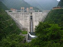
Fukashiro Dam
Appearance
| Fukashiro Dam | |
|---|---|
 | |
| Country | Japan |
| Location | Ōtsuki |
| Coordinates | 35°42′28″N 138°56′54″E / 35.70778°N 138.94833°E |
| Status | Operational |
| Construction began | 1996 |
| Opening date | 2004 |
| Dam and spillways | |
| Type of dam | Concrete gravity |
| Height | 87 m (285 ft) |
| Length | 164 m (538 ft) |
| Dam volume | 200,000 m3 (261,590 cu yd) |
| Spillway capacity | 790 m3/s (27,899 cu ft/s) |
| Reservoir | |
| Total capacity | 6,440,000 m3 (5,221 acre⋅ft) |
| Active capacity | 5,140,000 m3 (4,167 acre⋅ft) |
| Catchment area | 43.3 km2 (17 sq mi)[1] |
The Fukashiro Dam is a gravity dam in the Sagami River system, located 11 km (7 mi) north of Ōtsuki in Yamanashi Prefecture, Japan. The purpose of the dam is flood control and water supply. Plans for the dam were drawn up in 1978 and construction on the diversion tunnels began in 1996. The dam reached its height in 2001 and in 2003, the reservoir began to fill.[2] By 2004, the entire dam was complete. It is 87 m (285 ft) tall and 164 m (538 ft) long at the crest.[3] The dam's main spillway consists of five free overflow openings with a 790 m3/s (27,899 cu ft/s) discharge capacity. To handle additional discharges, there are two additional openings on the dam's orifice and two jet flow openings as part of the outlet works.[1]
See also
[edit]- Kazunogawa Pumped Storage Power Station – located upstream
References
[edit]- ^ a b "Fukashiro Dam" (in Japanese). Dam Mania. 7 April 2003. Retrieved 14 August 2011.
- ^ "Fukashiro Dam" (in Japanese). DamSite. Retrieved 14 August 2011.
- ^ "Fukashiro Dam" (in Japanese). Japan Dam Handbook. Retrieved 14 August 2011.
Wikimedia Commons has media related to Fukashiro Dam.

