Ba Đình district
Ba Dinh district
Quận Ba Đình | |
|---|---|
 | |
| Country | |
| Region | Red River Delta |
| Province | Hanoi |
| Liberation of Hanoi | 1954 |
| Urban district establishment | 1981 |
| Wards | 14 wards[1] |
| Government | |
| • Type | District-level government |
| • People's Committee President | Tạ Nam Chiến |
| • People's Council President | Nguyễn Công Thành |
| • District's Committee Secretary | Hoàng Minh Dũng Tiến |
| Area | |
• Total | 9.21 km2 (3.56 sq mi) |
| Population (2019)[2] | |
• Total | 221,893 |
| • Density | 24,000/km2 (62,000/sq mi) |
| GRDP (2023) | |
| • Non-governmental | 96,600 billion VND, US$4.03 billion[a] |
| Time zone | UTC+7 (ICT) |
| Postal code in Vietnam | 111xx |
| Area code | 24 |
| Website | badinh |
Ba Đình is one of the four original urban districts (quận) of Hanoi, the capital city of Vietnam.[4] The district currently has 14 wards, covering a total area of 9.21 square kilometres (3.56 sq mi).[1] As of 2019,[2] there were 221,893 people residing in the district, the population density is 24,000 inhabitants per square kilometer.
Ba Đình district has a large number of monuments, landmarks and relics, including Ho Chi Minh Mausoleum, One Pillar Pagoda, Flag Tower of Hanoi and Imperial Citadel of Thăng Long, a UNESCO World Heritage Site.
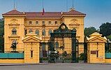
Ba Đình is the political center of Vietnam. Most of the government offices and embassies are located here including the most important sites of the Vietnamese state such as the Ba Đình Square, the Presidential Palace, the National Assembly Building, the Government Office and the Communist Party of Vietnam central headquarter. It was formerly called the "French Quarter" (Khu phố Pháp) because of a high concentration of French-styled villas and government buildings built when Hanoi was the capital of French Indochina. This name is still used in travel literature.[5] The southern half of Hoàn Kiếm district is also called the "French Quarter", also because of numerous French-styled buildings, most of which are now used as foreign embassies.
The wreckage of a B-52 bomber shot down during the Vietnam War can be seen in Hữu Tiệp Lake in the Ngọc Hà neighborhood.[6]
History
[edit]
One of the oldest remaining structures in the neighborhood is the One Pillar Pagoda, built under the Lý dynasty. In 1901, the Presidential Palace was built. On September 2, 1945, Ho Chi Minh read the Declaration of Independence at Ba Dinh Square to approximately 500,000 people. Following his death in 1969, the preserved body of Ho Chi Minh was put on display in the Hồ Chí Minh Mausoleum, located in Ba Dinh Square, in 1975.[7][8]
Location
[edit]
Ba Đình is located at 21° 2′ 12″ N, 105° 50′ 10″ E, in the center of Hanoi. It's surrounded to the north by Tây Hồ, to the east by the Red River, to the south by Đống Đa, to the southeast by Hoàn Kiếm and to the west by Cầu Giấy.
Administrative divisions
[edit]The district contains 14 wards (phường)
Education
[edit]This section needs expansion. You can help by adding to it. (October 2016) |
International schools:
- Hanoi International School
- Singapore International School in the Vạn Phúc Diplomatic Compound[9]
Gallery
[edit]-
Ministry of Foreign Affairs building
-
Lotte Center Hanoi in Cống Vị ward, western Ba Đình
-
A French Colonial villa in Ba Đình
Notes
[edit]- ^ Assuming average conversion rate of 24,000 VND = 1 USD in 2023
References
[edit]- ^ a b c "Niên giám thống kê năm 2018". Archived from the original on 2021-06-03. Retrieved 2021-02-21.
- ^ a b General Statistics Office of Vietnam (2019). "Completed Results of the 2019 Viet Nam Population and Housing Census" (PDF). Statistical Publishing House (Vietnam). ISBN 978-604-75-1532-5.
- ^ Tiến, Thành (5 January 2024). "Quận Ba Đình phấn đấu hoàn thành 139 chỉ tiêu nhiệm kỳ trong năm 2024". Hà Nội Mới (in Vietnamese). Retrieved 2024-09-13.
- ^ "Hà Nội có thêm năm quận mới vào năm 2025". VnExpress. 2019-10-30.
- ^ "French Quarter in Hanoi to be preserved", VietnamPlus, 18 Nov. 2010.
Downs, Tom, Hanoi & Halong Bay encounter (2007), p. 66. " "Much of the appeal of Hanoi's French Quarter is in its colonial architecture". - ^ "B-52 Wreckage". Atlas Obscura. Retrieved 2018-11-27.
- ^ "Ho Chi Minh Mausoleum". Atlas Obscura. Retrieved 2020-07-29.
- ^ "Rough Guides - Ba Dinh district". Rough Guides. Retrieved 2020-07-29.
- ^ "Contact Us".
21°02′12″N 105°50′10″E / 21.03667°N 105.83611°E


