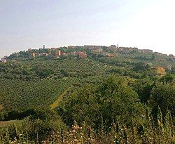
Flumeri
Appearance
You can help expand this article with text translated from the corresponding article in Italian. (January 2022) Click [show] for important translation instructions.
|
Flumeri | |
|---|---|
| Comune di Flumeri | |
 | |
| Coordinates: 41°4′44″N 15°8′55″E / 41.07889°N 15.14861°E | |
| Country | Italy |
| Region | Campania |
| Province | Avellino (AV) |
| Frazioni | Arcolento, Candelaro, Corridoio, Corvarana, Difesa, Laghi-Valle, Lagni, Murge, Pastinelli, Pilone, San Pietro, San Vito, Scampata, Tierzi, Tre Torri |
| Government | |
| • Mayor | Angelo Antonio Lanza |
| Area | |
• Total | 34.24 km2 (13.22 sq mi) |
| Elevation | 625 m (2,051 ft) |
| Population (31 August 2017)[2] | |
• Total | 2,950 |
| • Density | 86/km2 (220/sq mi) |
| Demonym | Flumeresi |
| Time zone | UTC+1 (CET) |
| • Summer (DST) | UTC+2 (CEST) |
| Postal code | 83040 |
| Dialing code | 0825 |
| Patron saint | St. Roch |
| Saint day | 6 December |
| Website | Official website |
Flumeri (Irpino: Flùmmërë) is a town and comune in the province of Avellino, Campania, southern Italy.
Located in the Apennines upon a knoll within the Ufita Valley, the town is part of the Roman Catholic Diocese of Ariano Irpino-Lacedonia. Its territory borders with the municipalities of Ariano Irpino, Castel Baronia, Frigento, Grottaminarda, San Nicola Baronia, San Sossio Baronia, Sturno, Villanova del Battista and Zungoli.
References
[edit]- ^ "Superficie di Comuni Province e Regioni italiane al 9 ottobre 2011". Italian National Institute of Statistics. Retrieved 16 March 2019.
- ^ All demographics and other statistics from the Italian statistical institute (Istat); Dati - Popolazione residente all'1/5/2009


