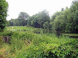
Finow
Appearance
You can help expand this article with text translated from the corresponding article in German. (September 2011) Click [show] for important translation instructions.
|
| Finow | |
|---|---|
 | |
 | |
| Location | |
| Country | Germany |
| State | Brandenburg |
| Physical characteristics | |
| Mouth | |
• location | Finow Canal |
• coordinates | 52°50′43″N 13°38′56″E / 52.84528°N 13.64889°E |
| Basin features | |
| Progression | Finow Canal→ Oder→ Baltic Sea |
Finow is a river of Brandenburg, Germany.[1] Originally, it flowed into the Oder near Oderberg, but since the creation of the Finow Canal in the 17th century, it flows into this canal near Finowfurt.

See also
[edit]References
[edit]- ^ "Landesamt für Umwelt, Gesundheit und Verbraucherschutz Abteilung Ökologie, Naturschutz, Wasser (ÖNW)" (PDF). Frag den Staat (in German). 24 March 2014. Retrieved 29 November 2024.
