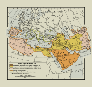
File:Arab Caliphate.svg
Appearance

Size of this PNG preview of this SVG file: 350 × 334 pixels. Other resolutions: 252 × 240 pixels | 503 × 480 pixels | 805 × 768 pixels | 1,073 × 1,024 pixels | 2,146 × 2,048 pixels.
Original file (SVG file, nominally 350 × 334 pixels, file size: 1.04 MB)
File history
Click on a date/time to view the file as it appeared at that time.
| Date/Time | Thumbnail | Dimensions | User | Comment | |
|---|---|---|---|---|---|
| current | 15:45, 15 October 2022 |  | 350 × 334 (1.04 MB) | Smasongarrison | slimmed down with svgomg: 1634.66k → 1065.11k 65.16% // Editing SVG source code using c:User:Rillke/SVGedit.js |
| 20:37, 23 September 2022 |  | 350 × 334 (1.6 MB) | Rattyrattery | Uploaded a work by William R. Shepherd from Historical Atlas with UploadWizard |
File usage
The following page uses this file:
Global file usage
The following other wikis use this file:
- Usage on uz.wikipedia.org
