Fermi (crater)
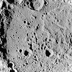
 Lunar Orbiter 3 image | |
| Coordinates | 19°37′S 123°14′E / 19.61°S 123.24°E |
|---|---|
| Diameter | 241.41 km (150.01 mi) |
| Depth | 5.5 km (3.4 mi)[1] |
| Colongitude | 240° at sunrise |
| Eponym | Enrico Fermi |


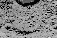
Fermi is a large lunar impact crater of the category named a walled plain. It was named after Italian-American physicist and Nobel laureate Enrico Fermi.[2] It lies on the far side of the Moon and can not be viewed from the Earth. Thus this feature must be viewed from an orbiting spacecraft.
The most notable aspect of Fermi is that the large and prominent crater Tsiolkovskiy intrudes into its southeastern rim. Unlike Tsiolkovskiy, however, the interior of Fermi is not covered by dark basaltic lava, and so it is barely distinguishable from the surrounding rugged and battered terrain. If it were located on the near side of the Moon, however, this would be one of the largest visible craters, with a dimension roughly equal to the crater Humboldt, lying several hundred kilometers to the west-southwest.
This formation has been significantly eroded and damaged by subsequent impacts, and several notable craters lie across the rim and within the basin. Delporte is the most notable of these, lying across the northwest rim. Just to the east and inside the northern rim of Fermi is Litke. The smaller crater Xenophon is centered across the southern rim. In the southern half of the floor are the craters Diderot and Babakin.
The rim, where it survives, is the most intact along the northern half. The southern half of the rim has been nearly obliterated, forming an irregular stretch of ground. The interior floor of Fermi has been modified by the creation of Tsiolkovskiy, with striations in the northeastern floor of Fermi, and parallel ridges along the western rim of Tsiolkovskiy. The remaining sections of the floor is somewhat more level, although pock-marked by myriads of tiny craterlets. The central section of the floor in particular has several clustered crater formations.
Prior to formal naming in 1970 by the IAU,[2] the crater was known as Basin V.[3]
References
[edit]- ^ LTO-101B1 Litke, Lunar Topographic Orthophotomap (LTO) Series, Publisher: Defense Mapping Agency, Scale: 1:250,000.
- ^ a b "Fermi (crater)". Gazetteer of Planetary Nomenclature. USGS Astrogeology Research Program.
- ^ Lunar Farside Chart (LFC-1A)
- Andersson, L. E.; Whitaker, E. A. (1982). NASA Catalogue of Lunar Nomenclature. NASA RP-1097.
- Bussey, B.; Spudis, P. (2004). The Clementine Atlas of the Moon. New York: Cambridge University Press. ISBN 978-0-521-81528-4.
- Cocks, Elijah E.; Cocks, Josiah C. (1995). Who's Who on the Moon: A Biographical Dictionary of Lunar Nomenclature. Tudor Publishers. ISBN 978-0-936389-27-1.
- McDowell, Jonathan (July 15, 2007). "Lunar Nomenclature". Jonathan's Space Report. Retrieved 2007-10-24.
- Menzel, D. H.; Minnaert, M.; Levin, B.; Dollfus, A.; Bell, B. (1971). "Report on Lunar Nomenclature by the Working Group of Commission 17 of the IAU". Space Science Reviews. 12 (2): 136–186. Bibcode:1971SSRv...12..136M. doi:10.1007/BF00171763. S2CID 122125855.
- Moore, Patrick (2001). On the Moon. Sterling Publishing Co. ISBN 978-0-304-35469-6.
- Price, Fred W. (1988). The Moon Observer's Handbook. Cambridge University Press. ISBN 978-0-521-33500-3.
- Rükl, Antonín (1990). Atlas of the Moon. Kalmbach Books. ISBN 978-0-913135-17-4.
- Webb, Rev. T. W. (1962). Celestial Objects for Common Telescopes (6th revised ed.). Dover. ISBN 978-0-486-20917-3.
- Whitaker, Ewen A. (1999). Mapping and Naming the Moon. Cambridge University Press. ISBN 978-0-521-62248-6.
- Wlasuk, Peter T. (2000). Observing the Moon. Springer. ISBN 978-1-85233-193-1.
External links
[edit]The following are L&PI topographic maps that show portions of Fermi.
- LTO-101B1 Litke — northern half
- LTO-101B4 Babakin — southern half

