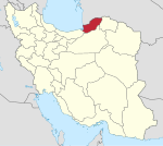
Estarabad-e Shomali Rural District
Appearance
Estarabad-e Shomali Rural District
Persian: دهستان استرآباد شمالي | |
|---|---|
| Coordinates: 36°53′41″N 54°31′30″E / 36.89472°N 54.52500°E[1] | |
| Country | Iran |
| Province | Golestan |
| County | Gorgan |
| District | Baharan |
| Capital | Sarkhon Kalateh |
| Population (2016)[2] | |
• Total | 17,513 |
| Time zone | UTC+3:30 (IRST) |
Estarabad-e Shomali Rural District (Persian: دهستان استرآباد شمالي) is in Baharan District of Gorgan County, Golestan province, Iran.[3] It is administered from the city of Sarkhon Kalateh.[4]
Demographics
[edit]Population
[edit]At the time of the 2006 National Census, the rural district's population was 17,553 in 4,423 households.[5] There were 17,680 inhabitants in 5,101 households at the following census of 2011.[6] The 2016 census measured the population of the rural district as 17,513 in 5,356 households. The most populous of its 17 villages was Alu Kalateh, with 2,572 people.[2]
See also
[edit]References
[edit]- ^ OpenStreetMap contributors (17 October 2024). "Estarabad-e Shomali Rural District (Gorgan County)" (Map). OpenStreetMap (in Persian). Retrieved 17 October 2024.
- ^ a b Census of the Islamic Republic of Iran, 1395 (2016): Golestan Province. amar.org.ir (Report) (in Persian). The Statistical Center of Iran. Archived from the original (Excel) on 29 March 2019. Retrieved 19 December 2022.
- ^ Habibi, Hassan (c. 2023) [Approved 31 January 1379]. Creating divisional changes and reforms in Golestan province. lamtakam.com (Report) (in Persian). Ministry of the Interior, Council of Ministers. Proposal 1.4.42.7194; Notification 31649/21627AH. Archived from the original on 18 December 2023. Retrieved 13 February 2024 – via Lam ta Kam.
- ^ Mousavi, Mirhossein (c. 2011) [Approved 2 February 1366]. Creation and formation of 10 rural districts including villages, farms and places located in Gorgan County, Mazandaran province. rc.majlis.ir (Report) (in Persian). Ministry of the Interior, Board of Ministers. Proposal 53.1.11473; Notification 110892/T386. Archived from the original on 19 October 2011. Retrieved 24 December 2023 – via Islamic Parliament Research Center.
- ^ Census of the Islamic Republic of Iran, 1385 (2006): Golestan Province. amar.org.ir (Report) (in Persian). The Statistical Center of Iran. Archived from the original (Excel) on 20 September 2011. Retrieved 25 September 2022.
- ^ Census of the Islamic Republic of Iran, 1390 (2011): Golestan Province. irandataportal.syr.edu (Report) (in Persian). The Statistical Center of Iran. Archived from the original (Excel) on 17 January 2023. Retrieved 19 December 2022 – via Iran Data Portal, Syracuse University.


