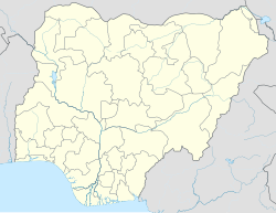
Enugu North
Enugu North | |
|---|---|
 Enugu North (red) in Enugu State (blue) | |
| Coordinates: 6°28′N 7°31′E / 6.467°N 7.517°E | |
| Country | |
| State | Enugu State |
| Government | |
| • Local Government Chairman | Emeka Onunze (PDP) |
| Area | |
• Total | 106 km2 (41 sq mi) |
| Population (2006 census) | |
• Total | 244,852 |
| Time zone | UTC+1 (WAT) |
| 3-digit postal code prefix | 400 |
| ISO 3166 code | NG.EN.EN |
 | |
Enugu North is a Local Government Area of Enugu State, Nigeria. Its headquarters are in the city of Enugu at Opkara Avenue. The LGA is made up of five main district areas Amaigbo Lane, Onuato, Umunevo, Enugwu-Ngwo and Ihenwuzi. Enugu North is one of the seventeen local governments in Enugu state and also one of the three LGA's that made up the Enugu Town - plus Enugu East and Enugu South.
It has an area of 106 km2 and a population of 244,852 at the 2006 census
The postal code of the area is 400.[1]
Geography
[edit]Enugu North LGA has a land size of 106 square kilometers, and a population of 244,852 at the 2006 census and an average temperature of 27 degrees Celsius. The area's average humidity is 69 percent, and the LGA has two distinct seasons: dry and rainy, with a brief harmattan in the dry season.[2]
Government
[edit]Wards
[edit]- Asata Township
- China Town
- G.R.A
- Ogui Newlayout
- Ihewuzi
- Independence Layout
- New Haven
- Ogbete East
- Ogbete West
- Ogui Township
- Onu-asata
- Udi Siding/Iva Valley/Hill-Top
- Umunevo
References
[edit]- ^ "Post Offices- with map of LGA". NIPOST. Archived from the original on 2009-10-07. Retrieved 2009-10-20.
- ^ "Enugu North Local Government Area". www.manpower.com.ng. Retrieved 2022-05-25.


