El Haouaria
You can help expand this article with text translated from the corresponding article in French. (February 2010) Click [show] for important translation instructions.
|
El Haouaria | |
|---|---|
Commune and town | |
 | |
 | |
| Country | |
| Governorate | Nabeul Governorate |
| Government | |
| • Mayor | Nawfel Miladi (Nidaa Tounes) |
| Population (2014) | |
• Total | 9,629 |
| Time zone | UTC+1 (CET) |
El Haouaria is a coastal town and commune in the Nabeul Governorate, situated in north-eastern Tunisia. As of 2004 it had a population of 9,273.[1]

History
[edit]El Haouaria, referred to by the Greeks as Hermaea, is first mentioned in the ancient Greek Periplus of Pseudo-Skylax (4th–3rd century BC). In this text, it is described as a polis (city) and recognized as one of the oldest maritime ports on the Cap Bon Peninsula.[2]
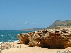
Caves of El Haouaria are located three kilometers west of the city, near the Ghar El Kebir site. These artificial quarries were probably dug by prisoners or slaves under the authority of the Carthaginians and later the Romans. The stone blocks extracted from them were transported by sea to Carthage, across the Gulf of Tunis. They were used to build the Punic city, as well as the construction of the forts in the Medina of Tunis.[2]
See also
[edit]References
[edit]- ^ (in French) Recensement de 2004 (Institut national de la statistique)
- ^ a b "The Quarries of El Haouaria". patrimoinedetunisie.com.tn. 2022-10-02. Retrieved 2024-12-20.
