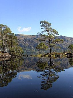
Eilean Ruairidh Mòr
Appearance
| Scottish Gaelic name | Eilean Ruairidh Mòr |
|---|---|
| Meaning of name | Island of Big Rory/Roderick |
 | |
| Location | |
| OS grid reference | NG897733 |
| Coordinates | 57°42′N 5°32′W / 57.7°N 5.53°W |
| Physical geography | |
| Island group | Loch Maree |
| Area | 38 ha[1] |
| Area rank | (Freshwater: 10) [2] |
| Highest elevation | 51 m |
| Administration | |
| Council area | Highland |
| Country | Scotland |
| Sovereign state | United Kingdom |
| Demographics | |
| Population | 0 |
| References | [3][4] |
Eilean Ruairidh Mòr is a forested island in Loch Maree, Wester Ross, Scotland. Its name was formerly anglicised as "Ellan-Rorymore".[5]
The island is owned by Forestry and Land Scotland, as is the Slattadale Forest on the southern shore of Loch Maree.[4] The islands in Loch Maree are among the least disturbed in Britain and are managed as a national nature reserve.[6]
History
[edit]Eilean Ruairidh Mòr was planted with pines in about 1815. There are remains of a subterranean circular structure,[5] similar to a Scandinavian dùn or burgh. The ancestors of the Mackenzies of Gairloch held it as a place of security from the attacks of the Macleods.[7]
Footnotes
[edit]- ^ Rick Livingstone’s Tables of the Islands of Scotland (pdf) Argyll Yacht Charters. Retrieved 12 Dec 2011.
- ^ Area and population ranks: there are c. 300 islands over 20 ha in extent and 93 permanently inhabited islands were listed in the 2011 census.
- ^ 2001 UK Census per List of islands of Scotland
- ^ a b Ordnance Survey. Landranger (1:50000) Series. Sheet 19: Gairloch and Ullapool.
- ^ a b Wilson, Rev. John The Gazetteer of Scotland (Edinburgh, 1882) Published by W. & A.K. Johnstone
- ^ "Loch Maree Islands National Nature Reserve". NatureScot. Retrieved 8 September 2020.
- ^ "Ordnance Gazetteer of Scotland". Electric Scotland. Retrieved 15 December 2007.
Wikimedia Commons has media related to Eilean Ruairidh Mòr.
57°42.05′N 5°31.75′W / 57.70083°N 5.52917°W


