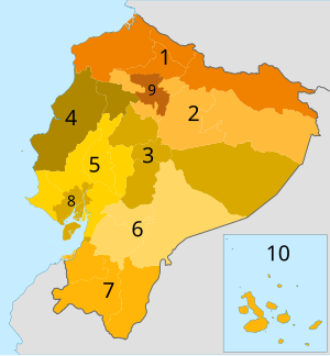
Ecuadorian Planning Zones
Appearance
This article has multiple issues. Please help improve it or discuss these issues on the talk page. (Learn how and when to remove these messages)
|

The planning zones of Ecuador are administrative organization entities made up of joint provinces or metropolitan districts in order to decentralize administrative activities of the Ecuadorian State.[1] The main agency in charge of zone planning is Senplades.
Planning zones
[edit]There are nine planning zones in Ecuador:[2]
- Ecuador Planning Zone 1 : Esmeraldas, Imbabura, Carchi, Sucumbíos
- Ecuador Planning Zone 2 : Pichincha, Napo, Orellana
- Ecuador Planning Zone 3 : Cotopaxi, Tungurahua, Chimborazo, Pastaza
- Ecuador Planning Zone 4 : Manabí, Santo Domingo de los Tsáchilas
- Ecuador Planning Zone 5 : Santa Elena, Guayas, Bolívar, Los Ríos, Galápagos
- Ecuador Planning Zone 6 : Cañar, Azuay, Morona Santiago
- Ecuador Planning Zone 7 : El Oro, Loja, Zamora Chinchipe
- Ecuador Planning Zone 8: Guayaquil, Samborondón, Durán
- Ecuador Planning Zone 9: Distrito Metropolitano de Quito
References
[edit]- ^ María Fernanda, López Sandoval (2015). "El sistema de planificación y el ordenamiento territorial para Buen Vivir en el Ecuador" (PDF). Geousp – Espaço e Tempo. 19 (2): 297-312. Retrieved 28 April 2023.
- ^ "Página web de la Senplades". Niveles de administración (in Spanish). Retrieved 30 March 2016.
