Draft:Peña de Martos
| This is a draft article. It is a work in progress open to editing by anyone. Please ensure core content policies are met before publishing it as a live Wikipedia article. Find sources: Google (books · news · scholar · free images · WP refs) · FENS · JSTOR · TWL Last edited by JTtheOG (talk | contribs) 3 seconds ago. (Update)
Finished drafting? or |
This article needs additional citations for verification. (January 2025) |
| Peña de Martos | |
|---|---|
 | |
| Highest point | |
| Elevation | 1,003 m (3,291 ft) |
| Prominence | 250 m (820 ft) |
| Listing | Rocky hill |
| Coordinates | 37°43′1″N 3°57′43″W / 37.71694°N 3.96194°W |
| Geography | |
 | |
| Country | Spain |
| Community | Andalusia |
| Province | Jaén |
| Municipality | Martos |
| Parent range | Prebaetic System |
| Climbing | |
| Easiest route | Hike |
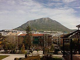
Peña de Martos (Spanish for Rock of Martos) is a 1,003-meter mountain in the Prebaetic System in Southern Spain. The city of Martos was built on its foot.
At its peak lie the ruins of a 10th century castle built by the Andalusi and later reconstructed by the Order of Calatrava. There is also a Christian cross commemorating the death of the Carvajal brothers, as legends say that they were thrown off this mountain after being sentenced to death by Ferdinand IV of Castile in 1312.
It originated in the Jurassic, when it broke away from the rest of the mountain range. It is composed of sedimentary rocks, mainly dolomites, whose chemical composition is calcium and magnesium carbonate.[1]
Due to its strategic location, it has been an important symbol of the city. However, it is not the tallest mountain in the municipality. It has appeared in several works, such as La Lozana andaluza by Francisco Delicado.
See also
[edit]References
[edit]- ^ Geocaching. "Peña de Martos".


