Dorion, Ontario
Appearance
Dorion | |
|---|---|
| Township of Dorion | |
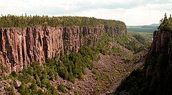
 Ouimet Canyon | |
| Coordinates: 48°47′N 88°36′W / 48.783°N 88.600°W | |
| Country | Canada |
| Province | Ontario |
| District | Thunder Bay |
| Settled | 1893 |
| Incorporated | 1969 |
| Government | |
| • Reeve | Robert Beatty |
| • Federal riding | Thunder Bay—Superior North |
| • Prov. riding | Thunder Bay—Superior North |
| Area | |
| • Land | 212.11 km2 (81.90 sq mi) |
| Population (2016)[1] | |
• Total | 316 |
| • Density | 1.5/km2 (4/sq mi) |
| Time zone | UTC-5 (EST) |
| • Summer (DST) | UTC-4 (EDT) |
| Postal Code FSA | P0T 1K0 |
| Area code | 807 (857 exchange) |
| Website | www.doriontownship.ca |
Dorion is a township in the Canadian province of Ontario, located within the Thunder Bay District. The township had a population of 316 in the Canada 2016 Census. Ouimet Canyon and the Dorion Bible Camp are located in the community.
Demographics
[edit]In the 2021 Census of Population conducted by Statistics Canada, Dorion had a population of 375 living in 160 of its 176 total private dwellings, a change of 18.7% from its 2016 population of 316. With a land area of 211.25 km2 (81.56 sq mi), it had a population density of 1.8/km2 (4.6/sq mi) in 2021.[2]
Canada census – Dorion community profile
| 2021 | 2016 | 2011 | |
|---|---|---|---|
| Population | 375 (+18.7% from 2016) | 316 (-6.5% from 2011) | 338 (-10.8% from 2006) |
| Land area | 211.25 km2 (81.56 sq mi) | 212.11 km2 (81.90 sq mi) | 212.12 km2 (81.90 sq mi) |
| Population density | 1.8/km2 (4.7/sq mi) | 1.5/km2 (3.9/sq mi) | 1.6/km2 (4.1/sq mi) |
| Median age | 56.4 (M: 57.6, F: 56.0) | 52.0 (M: 50.9, F: 52.1) | |
| Private dwellings | 176 (total) 160 (occupied) | 174 (total) | 154 (total) |
| Median household income | $91,000 | $79,360 |
| Year | Pop. | ±% |
|---|---|---|
| 1991 | 513 | — |
| 1996 | 472 | −8.0% |
| 2001 | 442 | −6.4% |
| 2006 | 379 | −14.3% |
| 2011 | 338 | −10.8% |
| 2016 | 316 | −6.5% |
| [8][5][1] | ||
See also
[edit]References
[edit]- ^ a b c "Census Profile, 2016 Census: Dorion, Township". Statistics Canada. 8 February 2017. Retrieved July 13, 2019.
- ^ "Population and dwelling counts: Canada, provinces and territories, census divisions and census subdivisions (municipalities), Ontario". Statistics Canada. February 9, 2022. Retrieved April 2, 2022.
- ^ "2021 Community Profiles". 2021 Canadian census. Statistics Canada. February 4, 2022. Retrieved 2023-10-19.
- ^ "2016 Community Profiles". 2016 Canadian census. Statistics Canada. August 12, 2021. Retrieved 2019-07-13.
- ^ a b "2011 Community Profiles". 2011 Canadian census. Statistics Canada. March 21, 2019. Retrieved 2012-03-29.
- ^ "2006 Community Profiles". 2006 Canadian census. Statistics Canada. August 20, 2019.
- ^ "2001 Community Profiles". 2001 Canadian census. Statistics Canada. July 18, 2021.
- ^ Statistics Canada: 1996, 2001, 2006, 2011 census
External links
[edit]


