Dewalapola
Dewalapola
දෙවලපොල தேவலபோல | |
|---|---|
town | |
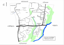
 Route map of Dewalapola | |
| Coordinates: 7°10′6″N 79°59′40″E / 7.16833°N 79.99444°E | |
| Country | Sri Lanka |
| Province | Western Province |
| District | Gampaha District |
| Government | |
| • Municipal Council | Minuwangoda |
| • Headquarters | Grama Niladhari Division (106) |
| Area | |
• Total | 15.00 km2 (5.79 sq mi) |
| Elevation | 23 m (75 ft) |
| Population | |
• Total | ~ 2,250 |
| • Density | 150/km2 (400/sq mi) |
| Time zone | UTC+05:30 (SLST) |
| Postal code | 11102 |
| Area code | 011 |
| Website | www |
Dewalapola is a small rural area in Minuwangoda Divisional Secretariate of Gampaha District,[1] Western Province, Sri Lanka. It is situated on the 245/1 Nittambuwa - Katunayake / Airport bus route between Veyangoda and Minuwangoda.
The major landuses in the area are rubber, coconut, MHG, rice and pineapples.[2] Dewalapola is the home of Sri Sudarshanarama Purana Viharaya,[3] Minu / Ananda Maha Vidyalaya (AMV), a public library, a post office[4] and an Ayurvedic Center of the Department Of Ayurveda, Ministry Of Indigenous Medicine.[5]
Etymology
[edit]The name Dewalapola is a compound formed of Dewele (of two times) and Pola (place) which means a place that used twice (a day). Accordance with the historical scripts found in Sri Lanka, for example Mahawamsa and Rajavaliya,[6] Udugampola Rajadhaniya (the Kingdom of Udugampola) was being ruled by King Sakalakala Wallabha[7] when his elder half brother, Buwanakabahu, owned the throne under the name of Dharma Parakramabahu IX(1508 AD - 1528 AD) of the Kingdom of Kotte succeeding his father King Veera Parakramabahu.[8]
King Sakalakala Wallabha with one of his Raja Shilpis, named Balasuriya Kankanama, the devoted superintendent of irrigation of the kingdom,[9] used to take rest for refreshments at Dewalapola twice a day on his way to and from the construction site of Mabodale wewa.[10]
Demographic
[edit]Population by Age
[edit]| Age Group | Number |
|---|---|
| 18>x | 974 |
| 18<x | 1252 |
| Total | 2226 |
As a percentage.
External links
[edit]- - Elevation of Dewalapola
- Source; The Electoral Registry -> Gampaha Electoral District / E - Minuwangoda / 17 - Dewalapola.[11]
See also
[edit]References
[edit]- ^ "Minuwangoda Divisional Secretariat".
- ^ "Climate of rice growing regions in Sri Lanka". Archived from the original on 2015-03-28. Retrieved 2015-01-17.
- ^ Ancient Preaching Hall in Dewalapola Sri Sudarshanarama (PDF). Archived from the original (PDF) on 2012-11-02. Retrieved 2015-01-17.
- ^ "Dewalapola Sub-Post Office".
- ^ "Department Of Ayurveda Ministry Of Indigenous Medicine".
- ^ "Rājāvaliya".
- ^ "The Kandyan Rebellion".
- ^ "Kotte Kingdom".
- ^ "Administration of the Udugampola Sub- kingdom : A Historical and Archaeological Legacy".
- ^ "One of the few irrigation tanks built by ancient kings in the Western Province of Sri Lanka".
- ^ "Gampaha District is divided into 13 Divisional Secretariat Divisions, 1177 GN Divisions and 1810 villages". Archived from the original on 2014-02-05.

