Dennehof, South Africa
Appearance
Dennehof | |
|---|---|
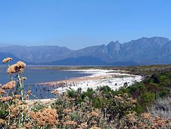
 The Theewaterskloof Dam near Dennehof. | |
| Coordinates: 34°02′20″S 19°17′20″E / 34.03889°S 19.28889°E | |
| Country | South Africa |
| Province | Western Cape |
| District | Overberg |
| Municipality | Theewaterskloof |
| Government | |
| • Councillor | Dawid Jooste[1] (DA) |
| Area | |
• Total | 1.09 km2 (0.42 sq mi) |
| Population (2011)[2] | |
• Total | 121 |
| • Density | 110/km2 (290/sq mi) |
| Racial makeup (2011) | |
| • Black African | 4.9% |
| • Coloured | 27.0% |
| • Indian/Asian | 3.3% |
| • White | 64.8% |
| First languages (2011) | |
| • Afrikaans | 53.7% |
| • English | 41.3% |
| • Other | 5.0% |
| Time zone | UTC+2 (SAST) |
| Postal code (street) | 2196 |
Dennehof is a settlement in Overberg District Municipality in the Western Cape province of South Africa.
References
[edit]- ^ Meet the Council - Ward 9
- ^ a b c d "Main Place Dennehof". Census 2011.


