Darling, Mississippi
Appearance
Darling, Mississippi | |
|---|---|
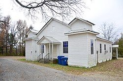
 Darling, Ms Greater Zion MB Baptist Church Historical African-American church | |
| Coordinates: 34°22′02″N 90°16′51″W / 34.36722°N 90.28083°W | |
| Country | United States |
| State | Mississippi |
| County | Quitman |
| Area | |
• Total | 2.71 sq mi (7.01 km2) |
| • Land | 2.71 sq mi (7.01 km2) |
| • Water | 0.00 sq mi (0.00 km2) |
| Elevation | 167 ft (51 m) |
| Population (2020) | |
• Total | 154 |
| • Density | 56.87/sq mi (21.96/km2) |
| Time zone | UTC-6 (Central (CST)) |
| • Summer (DST) | UTC-5 (CDT) |
| Area code | 662 |
| GNIS feature ID | 2586589[2] |
Darling is a census-designated place in Quitman County, Mississippi. Darling is located on Mississippi Highway 3, north of Marks. Per the 2020 Census, the population was 154.[3]
The settlement was named after Mr. Darling, a railroad official.[4]
Education
[edit]It is in the Quitman County School District.
Demographics
[edit]| Census | Pop. | Note | %± |
|---|---|---|---|
| 2010 | 226 | — | |
| 2020 | 154 | −31.9% | |
| U.S. Decennial Census[5] 2010[6] 2020[7] | |||
2020 census
[edit]| Race / Ethnicity (NH = Non-Hispanic) | Pop 2010[6] | Pop 2020[7] | % 2010 | % 2020 |
|---|---|---|---|---|
| White alone (NH) | 32 | 19 | 14.16% | 12.34% |
| Black or African American alone (NH) | 189 | 130 | 83.63% | 84.42% |
| Native American or Alaska Native alone (NH) | 0 | 0 | 0.00% | 0.00% |
| Asian alone (NH) | 0 | 1 | 0.00% | 0.65% |
| Pacific Islander alone (NH) | 0 | 0 | 0.00% | 0.00% |
| Some Other Race alone (NH) | 0 | 0 | 0.00% | 0.00% |
| Mixed Race or Multi-Racial (NH) | 0 | 4 | 0.00% | 2.60% |
| Hispanic or Latino (any race) | 5 | 0 | 2.21% | 0.00% |
| Total | 226 | 154 | 100.00% | 100.00% |
Transportation
[edit]Amtrak’s City of New Orleans, which operates between New Orleans and Chicago, passes through the town on CN tracks, but makes no stop. The nearest station is located in Marks, 7 miles (11 km) to the south.
References
[edit]- ^ "2020 U.S. Gazetteer Files". United States Census Bureau. Retrieved July 24, 2022.
- ^ a b U.S. Geological Survey Geographic Names Information System: Darling, Mississippi
- ^ "Darling CDP, Mississippi". United States Census Bureau. Retrieved March 13, 2022.
- ^ Moyer, Armond; Moyer, Winifred (1958). The origins of unusual place-names. Keystone Pub. Associates. p. 31.
- ^ "Decennial Census of Population and Housing by Decades". US Census Bureau.
- ^ a b "P2 Hispanic or Latino, and Not Hispanic or Latino by Race – 2010: DEC Redistricting Data (PL 94-171) – Darling CDP, Mississippi". United States Census Bureau.
- ^ a b "P2 Hispanic or Latino, and Not Hispanic or Latino by Race – 2020: DEC Redistricting Data (PL 94-171) – Darling CDP, Mississippi". United States Census Bureau.


