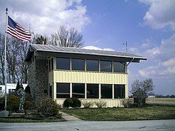
Darke County Airport
Darke County Airport | |||||||||||
|---|---|---|---|---|---|---|---|---|---|---|---|
 Airport building, used as a waiting area | |||||||||||
| Summary | |||||||||||
| Airport type | Public | ||||||||||
| Owner | Darke County Commissioners | ||||||||||
| Serves | Versailles, Ohio | ||||||||||
| Time zone | UTC−05:00 (-5) | ||||||||||
| • Summer (DST) | UTC−04:00 (-4) | ||||||||||
| Elevation AMSL | 1,007 ft / 307 m | ||||||||||
| Coordinates | 40°12′16″N 084°31′55″W / 40.20444°N 84.53194°W | ||||||||||
| Map | |||||||||||
 | |||||||||||
| Runways | |||||||||||
| |||||||||||
| Statistics (2021) | |||||||||||
| |||||||||||
Darke County Airport (ICAO: KVES, FAA LID: VES) is a county-owned, public-use airport in Darke County, Ohio, United States.[1] It is located two nautical miles (4 km) southwest of the central business district of Versailles.[1] It is along State Route 121 just south of Versailles. Midmark operates a private jet from this airport. The airport is included in the National Plan of Integrated Airport Systems for 2011–2015, which categorized it as a general aviation facility.[2]
Although most U.S. airports use the same three-letter location identifier for the FAA and IATA, this airport is assigned VES by the FAA,[1] but has no designation from the IATA.[3][4]
In 2007, light lenses were stolen from the airport. Officials said the theft could endanger pilots.[5]
The airport holds events such as fly-ins that feature old warbird aircraft, medical helicopters, and highway patrol aircraft.[6][7]
CareFlight Air & Mobile has a helicopter based at the airport, which serves as the company's northwest base. The helicopter was activated to respond to calls in early 2020.[8]
Facilities and aircraft
[edit]Facilities
[edit]Darke County Airport covers an area of 42 acres (17 ha) at an elevation of 1,007 feet (307 m) above mean sea level. It has one runway designated 9/27 with an asphalt surface measuring 4,802 by 75 feet (1,464 x 23 m).[1][9]
The airport has a fixed-base operator that sells both avgas and Jet A. Services such as hangars, courtesy cars, and rental cars are available; amenities such as internet, conference rooms, vending machines, a crew lounge, snooze rooms, and more are also available.[10]
In 2012, a section of State Route 242 was closed to allow the airport to use all of its runway surface for landings; with the road in place, planes need to approach at a higher altitude and touch down further down the runway to meet FAA obstacle clearance requirements.[11]
In 2022, the Dark County Airport received $1.35 million to upgrade its FBO terminal, including funding from the Bipartisan Infrastructure and Jobs Act.[12][13] Construction on the new airport terminal began in 2023, and a ribbon cutting ceremony to open the airport was held in spring 2024.[14] The facility aims at expanding the airport's attraction, especially as traffic increases.[15][16]
Additional funding was received in 2023 to improve the terminal's facilities.[17][18]
Aircraft
[edit]For the 12-month period ending September 29, 2021, the airport had 12,775 aircraft operations, an average of 35 per day: 87% general aviation, 5% air taxi, and <1% military. At that time there were 29 aircraft based at the airport: 25 single-engine and 2 multi-engine airplanes as well as 1 jet and 1 helicopter.[1][9]
Accidents & incidents
[edit]- On November 17, 2018, a Piper Saratoga crashed while landing at the Darke County Airport. Damage was done to the left wing and landing gear.[19][20]
See also
[edit]References
[edit]- ^ a b c d e f FAA Airport Form 5010 for VES PDF. Federal Aviation Administration. effective November 15, 2012.
- ^ "2011–2015 NPIAS Report, Appendix A" (PDF). National Plan of Integrated Airport Systems. Federal Aviation Administration. October 4, 2010. Archived from the original (PDF, 2.03 MB) on 2012-09-27.
- ^ "Darke County Airport (FAA: VES, ICAO: KVES, IATA: none)". Great Circle Mapper. Retrieved December 17, 2012.
- ^ "IATA Airport Code Search". International Air Transport Association. Retrieved December 16, 2012.
- ^ "Details on Darke County's Plans for State Route 242 and the Darke County Airport". Versailles, Ohio: The Columbus Dispatch. April 11, 2007. Retrieved 2024-05-14.
- ^ "Darke County Airport holds Fly-In – County News Online". 2023-09-26. Retrieved 2024-05-14.
- ^ "Darke County Airport Fly-In". AllEvents.in. Retrieved 2024-05-14.
- ^ "CareFlight adds fourth base of operations in Darke County". www.nationalaccountexecutives.com. Retrieved 2024-05-14.
- ^ a b "AirNav: KVES - Darke County Airport". www.airnav.com. Retrieved 2024-05-14.
- ^ "VES Darke County Airport (VES/KVES)". FlightAware. Retrieved 2024-05-14.
- ^ "Details on Darke County's Plans for State Route 242 and the Darke County Airport". Retrieved 2024-05-14.
- ^ Brewer, Meladi (2022-07-13). "Darke County receives $1.35 million for airport terminal". Daily Advocate & Early Bird News. Retrieved 2024-05-14.
- ^ Bush, John (July 11, 2022). "Darke County Airport lands $1.4 million in federal funding for new terminal building". Dayton Business Journal. The Business Journals. Retrieved 2024-05-14.
- ^ "Ribbon Cutting Celebrates Opening of New Darke County Airport Terminal – County News Online". 2024-04-30. Retrieved 2024-05-14.
- ^ Jarrell, Zachary (2023-08-30). "Construction of new terminal at Darke County Airport underway". WKEF. Retrieved 2024-05-14.
- ^ "'Able to offer much more': Darke County Airport builds new terminal". WDTN.com. 2023-09-01. Retrieved 2024-05-14.
- ^ Schrock, Jeffery (2023-04-29). "Five airports in southwest Ohio receive grant funding". WKEF. Retrieved 2024-05-14.
- ^ "Nearly $4 million in federal funds awarded to improve area airports". WHIO TV 7 and WHIO Radio. 2023-04-27. Retrieved 2024-05-14.
- ^ "Single engine aircraft crashes at Darke County Airport". Daily Advocate & Early Bird News. Versailles, Ohio. 2018-11-18. Retrieved 2024-05-14.
- ^ "Single engine aircraft crashes at Darke County Airport". Sidney Daily News. 2018-11-18. Retrieved 2024-05-14.
External links
[edit]- Aerial image as of April 1994 from USGS The National Map
- FAA Terminal Procedures for VES, effective December 26, 2024
- Resources for this airport:
- FAA airport information for VES
- AirNav airport information for KVES
- FlightAware airport information and live flight tracker
- NOAA/NWS weather observations: current, past three days
- SkyVector aeronautical chart, Terminal Procedures


