Dakshin Behala
Appearance
Dakshin Behala | |
|---|---|
Neighbourhood in Kolkata (Calcutta) | |
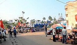
 Sasthir More, Dakshin Behala | |
| Coordinates: 22°28′11″N 88°17′51″E / 22.4696°N 88.2975°E | |
| Country | |
| State | West Bengal |
| City | Kolkata |
| District | Kolkata[1][2][3] |
| Metro Station | Thakurpukur, Sakherbazar |
| Municipal Corporation | Kolkata Municipal Corporation |
| KMC ward | 125, 126 |
| Population | |
• Total | For population see linked KMC ward page |
| Time zone | UTC+5:30 (IST) |
| PIN | 700 061 |
| Area code | +91 33 |
| Lok Sabha constituency | Kolkata Dakshin |
| Vidhan Sabha constituency | Behala Paschim |
Dakshin Behala is a locality of South West Kolkata in the Indian state of West Bengal. It is a part of greater Behala region. It is under the jurisdiction of Kolkata Police and Kolkata Municipal Corporation.
Location
[edit]Dakshin Behala borders Bakultala to the north and Anandanagar colony H Block to the south.
It composed of many small localities like Sastir more, Chandra Pally, Samsan Kalitala, Battala, Ghosh Para, Nator colony, Basudevpur, Bakultala, Basundhara Park, Ananda Nagar, Khudiram Pally, Dutta'r math area etc.
Administration
[edit]The area is under the jurisdiction of Thakurpukur Police Station and Sarsuna Police Station of South West Division (Behala Division) of Kolkata Police.[4]
Transportation
[edit]Bus
[edit]- M7C: Sasthir More - Howrah Station
- M7K: Khudiram Pally - Sealdah
Auto Routes
[edit]- Chandra Pally - Silpara
- Anandanagar - Thakurpukur
- Khudiram Pally - Thakurpukur
References
[edit]- ^ "Kolkata district".
- ^ "Electors Details As On 30-10-2010" (PDF). Archived from the original (PDF) on 29 May 2013.
- ^ "KMC Wards in South 24 Parganas".
- ^ "South West Division". Kolkata Police. Retrieved 12 December 2024.

