Dašice
Dašice | |
|---|---|
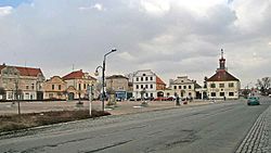
 Town square | |
| Coordinates: 50°1′48″N 15°54′47″E / 50.03000°N 15.91306°E | |
| Country | |
| Region | Pardubice |
| District | Pardubice |
| First mentioned | 1318 |
| Government | |
| • Mayor | Pavla Žídková |
| Area | |
• Total | 17.73 km2 (6.85 sq mi) |
| Elevation | 227 m (745 ft) |
| Population (2024-01-01)[1] | |
• Total | 2,642 |
| • Density | 150/km2 (390/sq mi) |
| Time zone | UTC+1 (CET) |
| • Summer (DST) | UTC+2 (CEST) |
| Postal codes | 530 02, 533 03 |
| Website | www |
Dašice (Czech pronunciation: [ˈdaʃɪtsɛ]) is a town in Pardubice District in the Pardubice Region of the Czech Republic. It has about 2,600 inhabitants. The historic town centre is well preserved and is protected by law as an urban monument zone.
Administrative parts
[edit]The villages of Malolánské, Prachovice, Velkolánské and Zminný are administrative parts of Dašice.
Etymology
[edit]The name is derived from the personal name Daš, meaning "the village of Daš's people".[2]
Geography
[edit]Dašice is located about 8 kilometres (5 mi) east of Pardubice. It lies in a flat landscape of the East Elbe Table, on the edge of the Polabí region. The Loučná River flows through the town.
History
[edit]
The first written mention of Dašice is from 1318. In 1437, Dašice was first referred to as a market town. In 1517, Dašice estate was acquired by the Pernštejn family and was annexed to the Pardubice estate. In 1917, Dašice was promoted to a town.[3]
Demographics
[edit]
|
|
| ||||||||||||||||||||||||||||||||||||||||||||||||||||||
| Source: Censuses[4][5] | ||||||||||||||||||||||||||||||||||||||||||||||||||||||||
Transport
[edit]The D35 motorway (part of the European route E442), which connects the D11 motorway with Olomouc, runs northeast of the town.
Sights
[edit]
The historic centre is formed by the large T. G. Masaryka Square with preserved burgher houses from the turn of the 18th and 19th centuries, characterized by late Rococo Empire facades.[6]
One of the main landmarks is the Church of the Nativity of the Virgin Mary. It is a Baroque basilica built in 1677–1707.[6]
A historical and technical monument is the Neo-Renaissance building of the water mill, in which two Francis turbines have been working non-stop since 1922.[6]
References
[edit]- ^ "Population of Municipalities – 1 January 2024". Czech Statistical Office. 2024-05-17.
- ^ Profous, Antonín (1947). Místní jména v Čechách I: A–H (in Czech). p. 366.
- ^ "Historie Dašic" (in Czech). Město Dašice. Retrieved 2021-10-12.
- ^ "Historický lexikon obcí České republiky 1869–2011" (in Czech). Czech Statistical Office. 2015-12-21.
- ^ "Population Census 2021: Population by sex". Public Database. Czech Statistical Office. 2021-03-27.
- ^ a b c "Město a dění ve městě" (in Czech). Město Dašice. Retrieved 2021-10-12.


