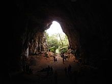
Cova des Coloms

Cova des Coloms (Cave of the pigeons in Catalan) is a natural cave located in the Spanish island Menorca, in the gully of Binigaus,[1] that has been declared Bien de Interés Cultural. Its ceiling stands about 24 m (79 ft) above the floor, it is 100 m (330 ft) deep and its entrance has a width of 15 m (49 ft). It can be reached by walk from the village of Es Migjorn Gran following the path that goes to the beach of Binigaus.[2]
Location
[edit]The cave is located in the gully of Binigaus, approximately 1 mile southeast from Es Migjorn Gran and access is free. The closest car park is by the local graveyard. The path is signposted in a private gravel road. In the crossing of the path that leads to the cave's entrance, the town hall has placed an information sign in Catalan, Spanish and English.
Description
[edit]
The cave is 110-metre-deep, 15-metre-wide and 24-metre-high.[3] For its sizes, it is also known as "the Cathedral". It is divided into two zones: the central room (about 50m deep) followed by a long and narrow corridor.
The cave was a burial site in the Talaiotic Period (550-123 ACN).[4] The French prehistorian Émile Cartailhac found in the 1890s ceramic and human bones. The excavation by Antonio Vives Escudero (1859-1925) in 1914-1915 found ceramic vessels and two bronze objects.[3]
The cave has been protected since 1966 as a Bien de Interés Cultural, with register number by the Spanish Ministry of Culture RI-51-0003660.
References
[edit]- ^ "Cova des Coloms". menorcadiferente.com. September 5, 2017.
- ^ "Rutes per la natura". Ajuntament d'Es Migjorn Gran. Retrieved September 5, 2017.
- ^ a b Information sign in the path to the cave, seen October 7, 2015.
- ^ Nicolau Martí, Antoni; Sintes Olives, Elena; Pla Boada, Ricard; Àlvarez Marsal, Albert (2015). Talayotic Menorca. The prehistory of the island. Sant Lluís. p. 237. ISBN 978-84-8478-640-5.
{{cite book}}: CS1 maint: location missing publisher (link)
External links
[edit]- How to get there
- Sa Cova d’es Coloms on the website Islas Baleares
