Chociwel
Chociwel | |
|---|---|
 Lake Starzyca and Our Lady of Sorrows church | |
| Coordinates: 53°27′58″N 15°20′23″E / 53.46611°N 15.33972°E | |
| Country | |
| Voivodeship | West Pomeranian |
| County | Stargard |
| Gmina | Chociwel |
| Town rights | 1338 |
| Government | |
| • Mayor | Stanisław Szymczak |
| Area | |
• Total | 3.67 km2 (1.42 sq mi) |
| Population (31 December 2021[1]) | |
• Total | 3,105 |
| • Density | 850/km2 (2,200/sq mi) |
| Time zone | UTC+1 (CET) |
| • Summer (DST) | UTC+2 (CEST) |
| Postal code | 73-120 |
| Area code | +48 91 |
| Vehicle registration | ZST |
| Website | http://www.chociwel.pl |
Chociwel [xɔˈt͡ɕivɛl] (Kashubian: Frinwôłd; German: Freienwalde in Pommern) is a town in northwestern Poland, in West Pomeranian Voivodeship, in Stargard County. As of December 2021, it has 3,105 inhabitants.[1]
History
[edit]
In the Middle Ages it was a Slavic gród. In 967 it became part of Poland under first historic ruler Mieszko I of Poland.[2] The first church was built around 1124.[3] The settlement was mentioned in 1190 and 1321.[4] In 1338 it was granted Magdeburg town rights and was known as Freienwalde. In the 15th century the town's main landmark was built – the Gothic Our Lady of Sorrows church.[3]
After the dissolution of the Duchy of Pomerania, in the mid-17th century it fell to the Margraviate of Brandenburg, then from 1701 it was part of Prussia, and from 1871 to 1945 it was part of Germany. It had a population of 3,406 in 1939. In 1945 it was awarded to Poland, along with most of Western Pomerania, at the insistence of Josef Stalin, and its entire population was expelled.[citation needed] Because of this, the population in 1946 was only 402, all of them Polish newcomers.[5] After the war, the town was given the name Chociwel, which is a modern version of the Old Polish name of the nearby lake Kotzavil, as it appeared in medieval documents. Among the settlers were Poles displaced from former eastern Poland annexed by the Soviet Union, Poles returning from forced labour both from the USSR and Germany and soldiers of the Polish Armed Forces in the West.
Demographics
[edit]Detailed data as of 31 December 2021:[1]
| Description | All | Women | Men | |||
|---|---|---|---|---|---|---|
| Unit | person | percentage | person | percentage | person | percentage |
| Population | 3105 | 100 | 1579 | 50.9% | 1526 | 41.1% |
| Population density | 846.0 | 430.2 | 415.8 | |||
Number of inhabitants by year
[edit]| Year | Population | Source |
|---|---|---|
| 1995 | 3254 |
[1] |
| 2000 | 3311 | |
| 2005 | 3303 | |
| 2010 | 3300 | |
| 2015 | 3196 | |
| 2020 | 3123 | |
| 2021 | 3105 |
Sports
[edit]The local football club is Piast Chociwel.[6] It competes in the lower leagues.
Gallery
[edit]-
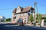
Municipal office
-
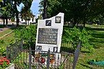
Polish First Army Memorial
-
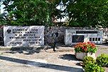
Baptist church
Notable residents
[edit]- Hugo von Kathen (1855–1932), general
- Herbert Hoffmann (1919–2010), artist
References
[edit]- ^ a b c d "Local Data Bank". Statistics Poland. Retrieved 2022-06-03. Data for territorial unit 3214024.
- ^ "O powiecie". BIP Starostwo Powiatowe w Stargardzie (in Polish). Archived from the original on 4 May 2021. Retrieved 5 December 2020.
- ^ a b "O parafii, Parafia rzymskokatolicka pw MB Bolesnej w Chociwlu" (in Polish). Retrieved July 8, 2019.
- ^ Czesław Piskorski, Pomorze Zachodnie, mały przewodnik, Wyd. Sport i Turystyka, Warszawa, 1980, p. 116 (in Polish)
- ^ Columbia-Lippincott Gazetteer. (New York: Columbia University Press, 1952) p. 403
- ^ "Piast Chociwel - strona klubu" (in Polish). Retrieved 5 December 2020.
External links
[edit]- Official town webpage
- Jewish Community in Chociwel on Virtual Shtetl


