Andrade, California
Andrade | |
|---|---|
| Coordinates: 32°43′33″N 114°43′33″W / 32.72583°N 114.72583°W | |
| Country | United States |
| State | California |
| County | Imperial County |
| Elevation | 138 ft (42 m) |
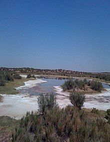
Andrade is a small locale in the southeasternmost corner of the state of California, in Imperial County. The community is located entirely within the Fort Yuma Indian Reservation. It is directly across the border from Los Algodones, the northernmost town of the municipality of Mexicali, in Baja California, and in all of Mexico. The ZIP Code is 92283. The community is inside area codes 442 and 760.
History
[edit]
Pilot Knob Station served as a stop on the San Antonio-San Diego Mail Line and Butterfield Overland Stage line and its successors until the railroad arrived in 1877.[2] The Pilot Knob Station was located at what is now Andrade, near the bank of the Colorado River at the foot of Pilot Knob, for which it was named.

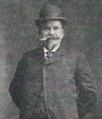
Andrade is named after Mexican General Guillermo Andrade (1833-1905). The General sold the land for the settlement to the California Development Company. The town was named in 1912 with establishment of the post office. Andrade was in the Navy, a diplomat and a banker.[3][4]
A post office operated at Andrade from 1909 to 1910 and from 1912 to 1942.[2] The name Cantu commemorated Col. Esteban Cantu, governor of the northernmost district of Baja California from 1915 to 1920.[2]
The Inter-California Railway formerly served Andrade.
The nearby Alamo Canal was built in 1901, the All-American Canal built in 1930s. California State Route 186 was built in 1917 and number assigned was given in 1972.[5][6][7]

In 2000, it had a population of 59, 74.6% of whom were Hispanic or Latino.[8] In 2016, the Sleepy Hollow RV Park in Andrade was closed by its owner, the Quechan Indian Tribe, over poor water quality.[9]
Climate
[edit]This area has a large amount of sunshine year round due to its stable descending air and high pressure. According to the Köppen Climate Classification system, Andrade has a desert climate, abbreviated "BWh" on climate maps.[10]
California Historical Landmark
[edit]| Charley's World of Lost Art | |
|---|---|
| Location | On dirt road about 0.5 miles Northwest of Andrade, California, by All-American Canal, Alamo Canal the Colorado River and California State Route 186. |
| Built | 1967 |
| Reference no. | 939.4 |
California Historical Landmark number 939.4, Charley's World of Lost Art is in Andrade, California. California Historical Landmark is part of the Twentieth Century Folk Art Environments collection. Built by Charles Kasling (1901-1985). Kasling had started creating art sculptures in 1959 and they cover about two 1/2 half acres. Kasling was inspired by both his travels with the U.S. Navy and his desert travels. He also built art in Death Valley.[11][12][13][14][15]
California Historical Landmark reads:
- NO. 939 Twentieth Century Folk Art Environments (Thematic) -CHARLEY'S WORLD OF LOST ART - Charles Kasling began sculpturing near Andrade in 1967, and his creations now fill a site of approximately two and a half acres. His style, best described as eclectic, was inspired partly by his world travels with the U.S. Navy and partly by the desert terrain. [16]
See also
[edit]- California Historical Landmarks in Imperial County
- Imperial County
- Imperial Valley
- Calexico–Mexicali
References
[edit]- ^ U.S. Geological Survey Geographic Names Information System: Andrade, California
- ^ a b c Durham, David L. (1998). California's Geographic Names: A Gazetteer of Historic and Modern Names of the State. Clovis, Calif.: Word Dancer Press. p. 1389. ISBN 1-884995-14-4.
- ^ Gudde, Erwin; William Bright (2004). California Place Names (Fourth ed.). University of California Press. p. 13. ISBN 0-520-24217-3.
- ^ General Guillermo Andrade
- ^ "Overview map of California State Route 186" (Map). Google Maps. Retrieved June 10, 2015.
- ^ California (Map). American Automobile Association. 1917. Retrieved June 21, 2014.
- ^ Staff (August 2010). "State-Route 186 Transportation Concept Summary" (PDF). Caltrans. p. 1. Retrieved June 21, 2014.
- ^ The entire population of Andrade is located within Block 2591, Block Group 2, Census Tract 124, Imperial County, California. Population figures are from US Census U.S. Census website .
- ^ Sleepy Hollow RV park nearly cleared out
- ^ Climate Summary for Andrade, California
- ^ Death Valley NPS, Driftwood Charlie’s Feet
- ^ Charley's World of Lost Art
- ^ Driftwood Charley's World of Lost ArtCharles Kasling (1901-1985)
- ^ Charley's World of Lost Art
- ^ Charley's World of Lost Art
- ^ californiahistoricallandmarks.com Landmark chl-939.4


