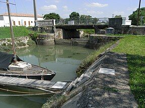
Charente-Seudre Canal
Appearance
| Canal de la Charente à la Seudre | |
|---|---|
 Last-lock in Marennes (17) Canal Charente Seudre (via the channel Marennnes) | |
 | |
| Specifications | |
| Length | 39 km (24 mi) |
| Locks | 5 |
| History | |
| Date completed | 1812 |
| Geography | |
| Start point | Charente (river) at Rochefort |
| End point | Seudre at Marennes |
| Beginning coordinates | 45°56′11″N 0°55′12″W / 45.93635°N 0.92010°W |
| Ending coordinates | 45°47′24″N 1°07′34″W / 45.79003°N 1.12610°W |
The Canal de la Charente à la Seudre (French pronunciation: [kanal də la ʃaʁɑ̃t a la sødʁ]), also called Canal de la Bridoire ([kanal də la bʁidwaʁ]), is a 39 km canal near the western shore of France. It connects the Charente (river) at Rochefort to the Seudre at Marennes.[1]
See also
[edit]References
[edit]- ^ McKnight, Hugh (2005). Cruising French Waterways, 4th Edition. Sheridan House. ISBN 978-1-57409-087-1.
External links
[edit]Wikimedia Commons has media related to Canal de la Charente à la Seudre.
