Chapeltown, Leeds
| Chapeltown | |
|---|---|
 Chapeltown Road | |
Location within West Yorkshire | |
| OS grid reference | SE3093435637 |
| Metropolitan borough | |
| Metropolitan county | |
| Region | |
| Country | England |
| Sovereign state | United Kingdom |
| Post town | LEEDS |
| Postcode district | LS7 |
| Dialling code | 0113 |
| Police | West Yorkshire |
| Fire | West Yorkshire |
| Ambulance | Yorkshire |
| UK Parliament | |
Chapeltown is a suburb of north-east Leeds, in West Yorkshire, England. It is part of the Leeds City Council Ward of Chapel Allerton.[1] It is approximately one mile north of Leeds city centre.
Location and boundaries
[edit]Chapeltown is an informally defined neighbourhood with no official boundaries. Ordnance Survey maps place Chapeltown at around National Grid Coordinates SE430500, 437500, south of Harehills Lane (B6159) and east of Scott Hall Road (A61).[2]

Chapeltown Road runs north through Potternewton to Harehills Lane – that is it leads to Chapeltown but is not on it.[3] A wider definition is it is in "the LS7 postal region, and can be mapped through four points; where Scott Hall Road runs to north to where it intersects with Potternewton Lane, where Harehills Lane runs east and intersects with Avenue Hill, where Spencer Place runs south and intersects with Roundhay Road, to the very bottom and beginning of Chapeltown Road."[4] The NHS Chapeltown Health Centre is at its south-east junction, the corner of Spencer Place and Leopold Street.
The Office for National Statistics define a Chapel Allerton South & Chapeltown statistical output area, which follows the LS7 postcode boundary on the east, with LS8 being Harehills.[5] Roundhay Road could also be considered the boundary between them. However, it is widely accepted that Markham Avenue and Gathorne Terrace are the dividing line between Chapeltown and Harehills.[citation needed] Harehills is adjacent, and the areas are commonly considered together.[6]
Neighbouring areas include Chapel Allerton to the north, Scott Hall to the west, Harehills to the east, Sheepscar to the south, and Potternewton either to the north or included. Taking the larger area, the main thoroughfare of Chapeltown is Chapeltown Road which passes through the centre of the area north–south for about 2 miles (3.2 km), linking Sheepscar Interchange (at the edge of Leeds city centre) and Harehills Lane/Chapel Allerton. Spencer Place in the east is another through route, and once well known as a red light district although the area's popularity with prostitutes has reportedly recently declined.[7]
Chapeltown and Potternewton
[edit]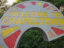
The names "Chapeltown" and "Potternewton" have become virtually interchangeable for the same area. The civil parish that governed the area before the expansion of Leeds County Borough in 1904 was called "Potter Newton",[8] and the name is still used by the Church of England for the ecclesiastical parish of St. Martin's Church.[9] The Ordnance Survey also lists the name "Potternewton" rather than "Chapeltown".[10] Royal Mail classifies the area around Oak Road and St Marys Close as Potternewton, but does not list any road as Chapeltown.[11] However, Leeds City Council now uses the name "Chapeltown" to refer to the area.[12][13]
Potternewton Park
[edit]Potternewton Park in the north-east of the area is the venue for Europe's oldest West Indian Carnival; Leeds Carnival. Norma Hutchinson Park, a smaller playground and sports field in the south of Chapeltown was previously named Buslingthorpe Recreation Ground and was renamed in 2009 to commemorate Jamaican-born local councillor, Norma Hutchinson, who died in 2004.[14]

Transport
[edit]Chapeltown is served by First Leeds' bus services 2, 3, 3A, 36 and 48, which run directly via Chapeltown Road. The hourly service 48 does not operate in the evenings or on Sundays. Service 91 (Pudsey-Halton Moor) runs along Harehills Lane.
Schools
[edit]
Bracken Edge Primary School is on Newton Garth adjacent to Potternewton Park. It was rebuilt and extended in 2007. Hillcrest Primary School, off Cowper Street has hosted events such as PFS (playing for success). Holy Rosary and St Annes Catholic School is on Leopold Street. Leopold Primary School, closed by 2002 because of overcrowding, became the Chapeltown Children Centre. Chapeltown Community Nursery is on Reginald Street.
History
[edit]The name Chapeltown is in origin a reduced form, first attested in 1427, of Chapel Allerton, and once denoted the same place.[15] Ralph Thoresby, writing in 1715, records Chapel-Town as a common name for the township of Chapel Allerton, describing it as "well situated in pure Air, upon a pleasant Ascent, which affords a Prospect of the Country ten or twelve miles". The open space to its east and north of Potter-Newton was "a delicate Green commonly call'd Chapel-Town Moor".[16]
Chapeltown Moor was in the manor of Newton (Potternewton), some 300 acres (120 hectares), used for races, archery contests, and in 1765 one of the first cricket matches in Yorkshire, between "the Gentlemen of Chapeltown and the Gentlemen of Sheffield".[17] By 1809, it was mostly enclosed.
In the 19th century, the area was developed as a wealthy suburb, and many large terraces and villas from the period remain, though a large proportion have fallen into disuse or are divided into smaller, low-rent flats. The area remains leafy and architecturally notable. Buildings have been adapted by successive communities who have settled in the area as places of worship and for a range of social uses. The Union Chapel on Chapeltown Road became a synagogue and then a Sikh temple, although it is now disused following a period of disrepair and fire damage. Chapeltown Barracks, now demolished, were completed in 1820.[18]
Development
[edit]

A map made of Leeds in 1834 shows that Chapeltown was pasture land between Chapel Allerton and Potternewton and Leeds and known as Potternewton. Through the centre of the farmland, which was earmarked as a planned "New Town" suburb, ran the Leeds-Harrogate Turnpike Road which later became Chapeltown Road. Much of the land, called "Squire's Pastures" belonged to Earl Cowper. He owned much land east of Chapeltown Road and some to the west. In the final decades of the 18th century and early decades of the 19th century legal disputes arose regarding the estates of the Barker/Ray family who had built Potternewton Hall "for the widow, Mrs Barker, to retire to" in the 1730s. They owned the estate, both the "upper house" (Potternewton Hall) and the "lower house" (Newton Hall) which was described by Ralph Thoresby, as a "venerable old fabric, standing low and shady". In "the first year of the sixteenth century", Low Hall (Newton Hall) had an estate worth 300 pounds a year.[19][20] In 1837, Darnton Lupton was the Mesne lord under Earl Cowper of Potternewton Hall Estate.[21]
Earl Cowper began selling land for development in 1825, but planning and building was slow, and the sale was not completed until 1873. The Earl also set out a Deed of Arrangement defining the residential character of any future building including the limitation of livestock, heavy industry and public houses.[22]
By 1866 the area east of Chapeltown Road and north of Roundhay Road had acquired streets of pleasant houses intended for the growing middle class, and known as New Leeds.[23]

Further north towards Potternewton work began in 1856 on Newton Grove where the Lupton family developed their Newton Park Estate following the designs of Charles Chorley and John Connon. The development expanded, including Sholebroke Avenue by the 1880s.[24][25]

St Martin's Church and shops on Chapeltown Road were built on Newton Park Estate land in the late 19th century. By the 1890s, the popularity of Chapeltown waned, in favour of areas further from the city. The remaining empty plots were filled with smaller, cheaper, terraced housing. By the start of the 20th century, the area was almost completely filled with housing. Newton Hall which had been the Lupton family residence was demolished in the 1920s. Potternewton Hall demolished c. 1935.[24][25] Little building work took place in Chapeltown throughout the 20th century, unlike many other areas which were subject to slum clearances. Neighbouring Harehills was much the same. One reason that could have led to Chapeltown being left was the quality of its housing stock, although they now largely achieve low rents, the houses are generally well built as they were originally built for the influx of Leeds' new middle class brought on by the industrial revolution.[23]
Population
[edit]
Over time Chapeltown has been home to successive émigré communities that have each added a new dimension to the culture, religious practices and heritage of the area.
Ashkenazi Jews fleeing pogroms in Eastern Europe towards the end of the 19th century moved to Leeds and settled in the inner city area of the Leylands.[26] Other groups of Jews also settled there, and synagogues were built. In the 20th century many of the community moved north to the more desirable area of New Leeds/Chapeltown, and so did their synagogues, at one time there were 14 in Chapeltown.[23] Along with neighbouring Harehills, where Montague Burton established his factory, Chapeltown was an important area for tailoring and allied trades, which occupied many Jews, and is remembered by the street name Button Hill.[23]
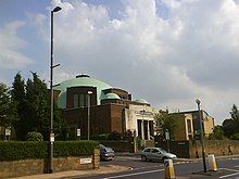
In 1932 the Chapeltown Road New Synagogue, a large domed Byzantine-style building, was opened.[27] The opening was in time for the High Festivals of that year, with Rabbi Hurwitz delivering that first Shabbat Shuvah sermon. The artist David Hillman was commissioned, in 1935, to design three stained-glass windows for the shul (synagogue) in commemoration of the Silver Jubilee of King George V. They have been moved to Shadwell Lane Synagogue.[27] In the following decades the Jewish population in Chapeltown declined as many families moved north to the Moortown area. In 1985 the synagogue closed and the building was bought by Leeds City Council.[27] It is now home to the Northern School of Contemporary Dance.
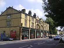
The British African-Caribbean community in Leeds mostly came to the UK between the end of the Second World War and the early 1960s. Many of the first Jamaicans to settle in Leeds were ex-servicemen. To encourage mass immigration from the countries of the British Empire and Commonwealth to fill shortages in the labour market, the 1948 British Nationality Act gave British citizenship to all people living in Commonwealth countries, and full rights of entry and settlement in Britain. Many of the first generation of Jamaicans living in Chapeltown today immigrated during this period.[28] The Jamaica Society was formed, with headquarters at 277 Chapeltown Road to support the needs and celebrate the contributions of the African-Caribbean population in West Yorkshire and Leeds.[29]
Recent history
[edit]In May 2003, Leeds City Council designated parts of Chapeltown/Potternewton as a conservation area in recognition of its special architectural and historic interest and to protect its character from harmful change. This enlarges the St Mary's Road (Chapeltown) conservation area on the former Newton Park Estate; this area being first designated in December 1974.
Around 2009/2010 the area became less run down with Spencer Place being prostitute free, the bus lane on Chapeltown Road being extended to serve the full length of the road, the addition of a bicycle lane, the decaying buildings getting repaired and the addition of the Reginald Centre, a joint service centre which replaces the original library in the area (similar to the Compton Centre in Harehills).[30]
There are many innovative Co-op housing associations[31] in Chapeltown[32] such as Cornerstone Housing Co-operative, 301 Housing Co-operative[33] and Chapeltown Cohousing.
Culture and environment
[edit]The area is home to a wide range of community and creative organisations including the Northern School of Contemporary Dance, the Chapeltown house choir, the Host Media centre, and Leeds West Indian Centre (now famous for its club nights, particularly the monthly SubDub).
Chapel Allerton Hospital is found in the area, and is one of Leeds' main hospitals, though it does not have an Accident and Emergency department.
Carnival
[edit]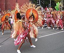
Every August bank holiday weekend the area hosts the Leeds Carnival, second only in size to London's Notting Hill Carnival, however Leeds Carnival started in 1967 and predates that of Notting Hill.[34] Arthur France, a Leeds University student from Saint Kitts helped to organise the first West Indian Carnival in Britain in Leeds in 1967. That year Vicki Celto was the first Carnival Queen for Leeds in a costume titled "Sun Goddess".[35]
Northern School of Contemporary Dance
[edit]The NSCD is a modern conservatoire dance school with its origins in the Leeds dance education of the 1970s and 1980s. Two years after the founding of the school in 1985, it moved to its current home in Chapeltown in 1987. The Riley Theatre was built in the former synagogue, and over the next ten years a number of new dance studios were created on the site and the Brandsby Lodge was renovated. Today the school is a contemporary dance institution with nearly 200 students.[36]
Crime
[edit]As a neighbourhood with a history of economic downturn, Chapeltown has been popularly associated with crime.[37] The area has suffered social problems, including street drug dealing and gun crime in the last decade.[38][39] However, Findaproperty.com states that Chapeltown's association with crime is "grossly exaggerated".[40] The Leeds Index of Deprivation ranked Chapeltown 20th out of 108 areas of the city for problems with community safety, and it is ranked as safer than most other inner-city areas of Leeds.[5]
In July 1981, it was one of the areas within cities that were home to race riots across England. There have been sporadic moments of social unrest since then including a riot in 1987.[41][42]
The most recent riot occurred on 29 July 1991, when around 100 youths went on a spree of looting and vandalism throughout the area. Police believed that the main culprits of the riot were members of a local drugs gang.[43]
During the 2011 England riots there were "small pockets of disorder"[44] in Chapeltown after a local man was shot in the face and later died in hospital; it was later confirmed that a group of 10–15 youths caused damage to three cars in the area.[45]
Religion
[edit]The changing population of the area is shown by the religious buildings, particularly along the Chapeltown Road. At the North end, by Chapel Allerton Hospital, is the 1976 Roman Catholic Church of Our Lady of Czestochowa & St. Stanislaw Kostka, serving the Polish community. (The Warsaw Stores on Chapeltown Road was a major source of Polish food in Leeds before a proliferation of Eastern European shops.) Further down is St Martin's Church, the original Anglican parish church of the village of Potternewton, now with a mainly West Indian congregation.[4] Then comes the Church of God of Prophecy, a Pentecostal church with a mainly Afro-Caribbean congregation.[4] Next door is the new Sikh Temple, the largest in Leeds.[4] Opposite, now out of use, is a church which was originally a Union Chapel, then a Synagogue and then a Sikh Temple until the new one was constructed. Near the South end, the Holy Rosary Church was built in 1937 for the Irish Catholic community.[17] Until 1985 the next building down was an impressive purpose-built synagogue, the largest in Leeds, which is now the Northern School of Contemporary Dance. The Roscoe Methodist Church on Francis Street (off Chapeltown Road) dates from 1974, but replaces a chapel founded in 1862.[46]
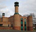
Elsewhere, a former United Reformed Church (1906) has become the Chapeltown Community Church by Potternewton Park. The Church of the Three Hierarchs in Harehills Avenue is a former Methodist chapel reopened as a Greek Orthodox church in 1966.[47] As late as 1993, maps showed four synagogues in the area[48] including the main one, but these have all closed. The first mosque in Leeds was created in a house in Leopold Street in 1961.[49] With the influx of Muslims from India and Pakistan in the 1960s and 1970s, larger buildings were acquired in 1974 and 1982 to become the main mosque in Leeds, and finally in 2001 the Central Jamia Mosque was completed on Spencer Place.[50]
-
Roman Catholic Church of Our Lady of Czestochowa & St. Stanislaw Kostka
-
St Martin's Church of England parish church
-
Church of God of Prophecy
-
Sikh Temple
-
Former chapel, synagogue and temple
-
Holy Rosary Roman Catholic Church
-
Chapeltown Community Church
-
Three Hierarchs Greek Orthodox Church
-
21 Leopold Street. A house then a synagogue then the first mosque in Leeds, now flats.
-
Leeds Jamia Mosque
-
House of Faith Blue Plaque Leopold Street
Notable residents of Chapeltown/Potternewton
[edit]- Frank Kidson (1855–1926), English folksong collector and music scholar, lived in Hamilton Avenue 1905–1926[51]
- Edward Caldwell Spruce (1865–1923), sculptor, had a studio in Cowper Street[52]
- Ellery Hanley MBE (born 1961), former Bradford Northern, Wigan, Balmain, Western Suburbs and Leeds Rugby League player and captain and later head coach of the Great Britain Rugby League team[53]
- Brian Deane (born 1968), former footballer[53]
- Olive Middleton née Lupton, great-grandmother of Catherine, Duchess of Cambridge who grew up at Newton Park Estate, Leeds
- Aaron Lennon (born 1987), footballer[54]
- Kulvinder Ghir (born 1965), actor and comedian
- Micah Richards (born 1988), footballer[54]
- Andre Wisdom (born 1993), footballer[54]
- Arthur Currer Briggs, Lord Mayor of Leeds, 1903[55][56]
- Eileen Taylor, Lord Mayor of Leeds from 2019 to 2021
- Cedric Clarke - Leeds' first black councillor[57]
Location grid
[edit]See also
[edit]Notes and references
[edit]- ^ "ArcGIS Web Application". leedscc.maps.arcgis.com. Retrieved 2 March 2019.
- ^ Checked online, but also in publications derived from OS, such as AZ Leeds and Bradford Street Atlas (1993) Geographers' A-Z Map Company Ltd, ISBN 978-0-85039-285-2
- ^ Likewise Potternewton Lane leads to Potternewton, Roundhay Road leads to Roundhay etc.
- ^ a b c d Religious Mapping of Chapeltown 2007 R. D. Fotiou et al.
- ^ a b "E02002371: Chapeltown" (PDF). Archived from the original (PDF) on 29 September 2011. Retrieved 1 January 2011.
- ^ G, Genna (26 May 2006). "Round my way". BBC Leeds. Retrieved 16 May 2008.
- ^ Edwards, Richard. "Still trapped in vice". Yorkshire Evening Post. Retrieved 6 July 2008.
- ^ "Potter Newton Tn/CP". Vision of Britain. Retrieved 12 July 2020.
- ^ "St. Martin's Church, Leeds". Retrieved 12 July 2020.
- ^ "List of all the places in Leeds". Ordnance Survey. Retrieved 12 July 2020.
- ^ "Royal Mail: postcode finder". Retrieved 17 October 2020.
- ^ "Chapeltown, Leeds: Conservation Area Extension Appraisal" (PDF). Leeds City Council. October 2007. Retrieved 12 July 2020.
- ^ "Chapeltown Neighbourhood Plan". Leeds City Council. Retrieved 12 July 2020.
- ^ [1][permanent dead link]
- ^ A. H. Smith, The Place-Names of the West Riding of Yorkshire, English Place-Names Society, 30–37, 8 vols (Cambridge: Cambridge University Press, 1961–63), iv, 138.
- ^ Ralph Thoresby (1715) Ducatus Leodiensis: or, the topography of the ancient and populous town and parish of Leedes, and parts adjacent in the West Riding of York, pages 113, 124
- ^ a b "Holy Rosary Church Leeds: Silver Jubilee 1937-1962" (PDF). Movinghere.org.uk. Retrieved 8 October 2019.
- ^ "Timeline History of Leeds". Visitor UK. Retrieved 9 October 2016.
- ^ Barker, E. (1821). "The Will of M. A. M. Faber, with Facts and Observations Proving Its ..." Edmund Henry Barker 1821. pp. 24–28. Retrieved 15 January 2019.
- ^ Parsons, E. (1834). "The Civil, Ecclesiastical, Literary, Commercial, and Miscellaneous History of Leeds, Halifax, Huddersfield, Bradford, Wakefield, Dewsbury, Otley". F. Hobson 1834. p. 202. Retrieved 15 January 2019.
Newton Hall (otherwise Low Hall)
- ^ (England), Leeds (1837). The Poll Book of the Leeds Borough Election, July, 1837. p. 28. Retrieved 3 September 2019.
Lupton, Darnton, House and land, Potternewton Hall
- ^ "Leopold Street history". Latch. Archived from the original on 1 September 2007. Retrieved 6 July 2008.
- ^ a b c d Murray Freedman (2002) Chapeltown and its Jews (M. P. Freedman)
- ^ a b Historic England. "Former lodge to Newton Hall with gate piers and flanking wall (1255604)". National Heritage List for England. Retrieved 27 December 2015.
- ^ a b Conservation Area Appraisal, Chapeltown. "Chapeltown Conservation Area Appraisal" (PDF). UK GOV. Leeds City Council. Archived from the original (PDF) on 3 September 2014. Retrieved 29 August 2013.
- ^ Seigel, Carol. "Migration Histories: Jewish – Settling". movinghere.org.uk. Retrieved 28 August 2008.
- ^ a b c Freedman, Murray. "Chapeltown Road New Synagogue". UHC 150th Anniversary Brochure Leeds. Retrieved 28 August 2008.
- ^ Walker, Melody. "A journey through history" (PDF). Jamaica Society (Leeds) Publication. Archived from the original (PDF) on 22 August 2006. Retrieved 9 September 2008.
- ^ "The Jamaican Society: Case Study". Local Heritage Initiative. 20 November 2008. Archived from the original on 20 November 2008. Retrieved 8 October 2019.
- ^ "Chapeltown Conservation Area Appraisal" (PDF). Development Department, Leeds City Council. 21 May 2003. Archived from the original (PDF) on 10 June 2011. Retrieved 6 July 2008.
- ^ "Leeds Housing Cooperatives". Leedshousingcoops.blogspot.com. Retrieved 2 March 2019.
- ^ "Leeds housing focus: The co-operative solution to affordable housing woes". Yorkshire Evening Post. Retrieved 2 March 2019.
- ^ "301 Housing Co-operative | Diggers and Dreamers". Diggersanddreamers.org.uk. Retrieved 2 March 2019.
- ^ Farrar, Max (2000). "A Short History of the Leeds West Indian Carnival, between 1967 and 2000" (PDF). West Yorkshire Archive Service. Archived from the original (PDF) on 20 November 2008. Retrieved 28 August 2008.
- ^ "Carnival Through the Years, 1967". Leeds West Indian Carnival Website. Archived from the original on 11 November 2007. Retrieved 6 July 2008.
- ^ "Northern School of Contemporary Dance: History". Archived from the original on 24 February 2014. Retrieved 9 September 2008.
- ^ "Leeds – Civic Life – Round my way". BBC. Retrieved 8 October 2019.
- ^ "New CCTV over father's gun death". BBC News. 5 August 2008. Retrieved 28 April 2010.
- ^ Bruce, David. "500 police swoop on Chapeltown". Yorkshire Evening Post. Retrieved 6 July 2008.
- ^ "Property for Sale in LS7 – Buy Properties in LS7". Zoopla.
- ^ "'No excuse' for Leeds riot". BBC News. 6 June 2001. Retrieved 6 July 2008.
- ^ "Programmes – Most Popular – All 4". Channel 4. Retrieved 8 October 2019.
- ^ [2][permanent dead link]
- ^ "UK riots: Trouble erupts in English cities". BBC News. 10 August 2011. Retrieved 17 January 2012.
Police dealt with "small pockets of disorder" in the Chapeltown area of Leeds
- ^ Clifton, Helen (2 July 2012). "How Leeds avoided the worst of the riots". TheGuardian.com. Retrieved 2 March 2019.
- ^ Hudson, Neil (8 October 2011). "The Leeds church that changed with the times". Yorkshire Evening Post. Archived from the original on 8 January 2016. Retrieved 26 April 2015.
- ^ "Brief History". Greek Community of Leeds. 4 January 2009. Archived from the original on 25 April 2008. Retrieved 24 January 2009.
- ^ AZ Leeds and Bradford Street Atlas (1993) Geographers' A-Z Map Co Ltd ISBN 978-0-85039-285-2
- ^ Yorkshire Evening Post 15 March 2012 Blue plaque for historic Leeds property
- ^ Leeds Islamic Centre Brief History of Leeds Islamic Centre
- ^ "Frank Kidson (1855–1926)". They lived in Leeds. Thoresby Society. Retrieved 1 October 2017.
- ^ www.leodis.net Cowper Street Studio of Edward Caldwell Spruce
- ^ a b Freeman, Mr. (December 1995). "Positive News" (PDF). Community Highlight: the Newsletter for Chapeltown. No. 1. p. 2. Retrieved 1 October 2017.
- ^ a b c Jolly, Richard (17 October 2012). "Andre Wisdom proving to be an apt pupil for Anfield". The National. UAE. Retrieved 1 October 2017.
- ^ "Lord Mayor of Leeds". Leeds City Council. Retrieved 8 September 2012. General information about current Lord Mayor
- ^ "Lord Mayors & Aldermen of Leeds since 1626" (PDF). Leeds City Council. Retrieved 1 November 2017.
- ^ BBC. "Gallic flair". www.bbc.co.uk. Retrieved 9 November 2020.
External links
[edit]- Arthur France MBE – Moving Here Stories
- Max Farrar The Zone of the Other: Imposing and Resisting Alien Identities in Chapeltown, Leeds, During the Twentieth Century
- Chapeltown Carnival Queen 2005 Flickr
- Chapeltown Carnival Leeds 2004 Flickr
- "The Ancient Parish of Leeds". GENUKI. Historical and genealogical resource for area including Chapeltown


