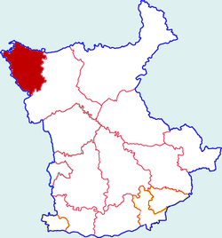
Changwu County
Appearance
Changwu County
长武县 | |
|---|---|
 Changwu in Xianyang | |
 Xianyang in Shaanxi | |
| Country | People's Republic of China |
| Province | Shaanxi |
| Prefecture-level city | Xianyang |
| Area | |
• Total | 567.3 km2 (219.0 sq mi) |
| Population (2016) | |
• Total | 170,878 |
| • Density | 300/km2 (780/sq mi) |
| Time zone | UTC+8 (China standard time) |
| Postal Code | 713600 |
Changwu County (simplified Chinese: 长武县; traditional Chinese: 長武縣; pinyin: Chángwǔ Xiàn) is a county in the central part of Shaanxi province, China, bordering Gansu province to the north, west, and southwest. It is under the administration and occupies the northwest corner of Xianyang City.
Administrative divisions
[edit]One subdistrict:[1]
- Zhaoren Subdistrict (昭仁街道)
- Xianggong (相公镇), Jujia (巨家镇), Dingjia (丁家镇), Hongjia (洪家镇), Tingkou (亭口镇), Penggong (彭公镇), Zaoyuan (枣园镇)
Climate
[edit]| Climate data for Changwu, elevation 1,207 m (3,960 ft), (1991–2020 normals, extremes 1981–2010) | |||||||||||||
|---|---|---|---|---|---|---|---|---|---|---|---|---|---|
| Month | Jan | Feb | Mar | Apr | May | Jun | Jul | Aug | Sep | Oct | Nov | Dec | Year |
| Record high °C (°F) | 14.2 (57.6) |
21.3 (70.3) |
27.8 (82.0) |
33.2 (91.8) |
33.9 (93.0) |
36.1 (97.0) |
37.6 (99.7) |
34.4 (93.9) |
34.4 (93.9) |
28.7 (83.7) |
21.1 (70.0) |
17.1 (62.8) |
37.6 (99.7) |
| Mean daily maximum °C (°F) | 1.9 (35.4) |
5.8 (42.4) |
12.0 (53.6) |
18.8 (65.8) |
22.9 (73.2) |
26.8 (80.2) |
28.1 (82.6) |
26.2 (79.2) |
21.2 (70.2) |
15.4 (59.7) |
9.4 (48.9) |
3.4 (38.1) |
16.0 (60.8) |
| Daily mean °C (°F) | −4.4 (24.1) |
−0.4 (31.3) |
5.5 (41.9) |
11.8 (53.2) |
16.1 (61.0) |
20.3 (68.5) |
22.3 (72.1) |
20.6 (69.1) |
15.7 (60.3) |
9.4 (48.9) |
2.9 (37.2) |
−2.7 (27.1) |
9.8 (49.6) |
| Mean daily minimum °C (°F) | −9.3 (15.3) |
−5.1 (22.8) |
0.3 (32.5) |
5.4 (41.7) |
9.5 (49.1) |
14.1 (57.4) |
17.3 (63.1) |
16.3 (61.3) |
11.5 (52.7) |
4.9 (40.8) |
−1.8 (28.8) |
−7.4 (18.7) |
4.6 (40.4) |
| Record low °C (°F) | −24.6 (−12.3) |
−22.8 (−9.0) |
−12.5 (9.5) |
−6.6 (20.1) |
−1.7 (28.9) |
4.0 (39.2) |
9.0 (48.2) |
5.7 (42.3) |
0.9 (33.6) |
−8.5 (16.7) |
−18.9 (−2.0) |
−26.2 (−15.2) |
−26.2 (−15.2) |
| Average precipitation mm (inches) | 8.2 (0.32) |
10.6 (0.42) |
22.3 (0.88) |
35.5 (1.40) |
53.3 (2.10) |
72.0 (2.83) |
105.8 (4.17) |
113.0 (4.45) |
91.3 (3.59) |
49.0 (1.93) |
17.5 (0.69) |
4.8 (0.19) |
583.3 (22.97) |
| Average precipitation days (≥ 0.1 mm) | 5.0 | 5.3 | 6.6 | 7.2 | 9.9 | 10.0 | 11.2 | 12.2 | 12.3 | 10.2 | 5.8 | 3.7 | 99.4 |
| Average snowy days | 6.4 | 6.5 | 4.2 | 0.8 | 0 | 0 | 0 | 0 | 0 | 0.6 | 3.4 | 4.9 | 26.8 |
| Average relative humidity (%) | 60 | 60 | 58 | 58 | 62 | 66 | 74 | 80 | 81 | 79 | 71 | 62 | 68 |
| Mean monthly sunshine hours | 176.0 | 158.6 | 181.4 | 204.9 | 219.3 | 211.6 | 208.1 | 185.7 | 135.3 | 140.5 | 162.7 | 180.4 | 2,164.5 |
| Percent possible sunshine | 56 | 51 | 49 | 52 | 50 | 49 | 48 | 45 | 37 | 41 | 53 | 60 | 49 |
| Source: China Meteorological Administration[2][3] | |||||||||||||
Transport
[edit]References
[edit]- ^ a b 2017年统计用区划代码和城乡划分代码:长武县 (in Chinese). National Bureau of Statistics of the People's Republic of China. 2017. Retrieved 2018-08-01.
统计用区划代码 名称 610428001000 昭仁街道办事处 610428101000 相公镇 610428102000 巨家镇 610428103000 丁家镇 610428104000 洪家镇 610428105000 亭口镇 610428106000 彭公镇 610428108000 枣园镇
- ^ 中国气象数据网 – WeatherBk Data (in Simplified Chinese). China Meteorological Administration. Retrieved 26 August 2023.
- ^ 中国气象数据网 (in Simplified Chinese). China Meteorological Administration. Retrieved 26 August 2023.
35°08′55″N 107°59′02″E / 35.1486°N 107.984°E
