Central McDougall
Central McDougall | |
|---|---|
Neighbourhood | |
Location of Central McDougall in Edmonton | |
| Coordinates: 53°33′15″N 113°30′00″W / 53.55417°N 113.50000°W[1] | |
| Country | Canada |
| Province | Alberta |
| City | Edmonton |
| Quadrant[2] | NW |
| Ward[2] | O-day’min |
| Sector[3] | Mature area |
| Area[4] | Central core |
| Government | |
| • Administrative body | Edmonton City Council |
| • Councillor | Anne Stevenson |
| Area | |
• Total | 1.21 km2 (0.47 sq mi) |
| Elevation | 665 m (2,182 ft) |
| Population (2012)[7] | |
• Total | 4,712 |
| • Density | 3,894.2/km2 (10,086/sq mi) |
| • Change (2009–12) | |
| • Dwellings | 3,363 |
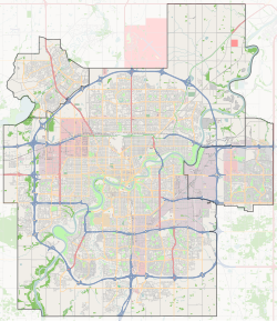
Central McDougall is a largely residential neighbourhood in the City of Edmonton, Alberta, Canada located immediately north of the downtown core.
Located within the neighbourhood are the Royal Alexandra Hospital, the Prince of Wales Armouries Heritage Centre, the Victoria School of the Arts, and the administrative offices of the Edmonton Public Schools system. Kingsway Mall is located immediately to the north of Central McDougall in the neighbourhood of Spruce Avenue, as is the Glenrose Rehabilitation Hospital and the Norwood Extended Care Centre North.
The neighbourhood is bounded on the north by 111 Avenue, on the south by 105 Avenue, on the east by 101 Street and on the west by 109 Street. Running through Central McDougall is Kingsway Avenue.
The community is represented on the Edmonton Federation of Community Leagues by the Central McDougall Community League, established in 1923.[8][9]
Demographics
[edit]In the City of Edmonton's 2012 municipal census, Central McDougall had a population of 4,712 living in 3,363 dwellings,[7] a 9.6% decrease from its 2009 population of 5,212.[10] With a land area of 1.21 km2 (0.47 sq mi), it had a population density of 3,894.2/km2 (10,086.0/sq mi) in 2012.[6][7]
Central McDougall is one of Edmonton's lower income neighbourhoods, with an average household income that is significantly below that of households in Edmonton at large.
| Income by household - 2001 census[11][12] | ||
| Income range ($) | Central McDougall | Edmonton |
| (% of households) | (% of households) | |
| Under $10,000 | 16.23% | 6.3% |
| $10,000-$19,999 | 28.7% | 12.4% |
| $20,000-$29,999 | 20.42% | 11.9% |
| $30,000-$39,999 | 14.8% | 11.8% |
| $40,000-$49,999 | 8.7% | 10.9% |
| $50,000-$59,999 | 4.8% | 9.5% |
| $60,000-$69,999 | 3.4% | 8.3% |
| $70,000-$79,999 | 1.1% | 6.7% |
| $80,000-$89,999 | 1.0% | 5.4% |
| $90,000-$99,999 | 0.4% | 4.2% |
| $100,000 and over | 0.6% | 12.6% |
| Average household income | $26,302 | $57,360 |
Future developments
[edit]Central McDougall and neighbouring Queen Mary Park are part of the city's "North Edge" redevelopment plan (north edge here refers to the northern edge of the downtown, not of the city), which will see the construction of several new condominium towers.[15]
Currently there are plans for a new residential condominium complex called Aurora located at the south end of the neighbourhood. The Aurora will be located on a parcel of land bounded by 105 Avenue on the south, 106 Avenue on the north, 102 Street on the east, and 103 Street on the west.
When complete, this project, with an estimated value of over half a billion dollars, will add five high rise towers to the Edmonton skyline. In addition, the proposal includes another three low rise buildings. The completed project will have 1,220 housing units and a retail component.[16]
Surrounding neighbourhoods
[edit]References
[edit]- ^ "Central McDougall". Geographical Names Data Base. Natural Resources Canada.
- ^ a b "City of Edmonton Wards & Standard Neighbourhoods" (PDF). City of Edmonton. Archived from the original (PDF) on May 3, 2014. Retrieved February 13, 2013.
- ^ "Edmonton Developing and Planned Neighbourhoods, 2011" (PDF). City of Edmonton. Archived from the original (PDF) on September 4, 2013. Retrieved February 13, 2013.
- ^ "The Way We Grow: Municipal Development Plan Bylaw 15100" (PDF). City of Edmonton. 2010-05-26. Archived from the original (PDF) on May 2, 2015. Retrieved February 13, 2013.
- ^ "City Councillors". City of Edmonton. Retrieved February 13, 2013.
- ^ a b "Neighbourhoods (data plus kml file)". City of Edmonton. Retrieved February 13, 2013.
- ^ a b c "Municipal Census Results – Edmonton 2012 Census". City of Edmonton. Retrieved February 22, 2013.
- ^ "Central McDougall Community League". Central McDougall Community League. Retrieved October 7, 2017.
- ^ Kuban, Ron (2005). Edmonton's Urban Villages: The Community League Movement. University of Alberta Press. ISBN 9781459303249.
- ^ "2009 Municipal Census Results". City of Edmonton. Retrieved February 22, 2013.
- ^ 2000 dollars
- ^ Income is for all persons in the household. So, if there are two persons in the household and each person earns $15,000, the household income is $30,000
- ^ City of Edmonton. "2001 Federal Census Income by Households: Central McDougall" (PDF). City of Edmonton. Retrieved September 21, 2011.
- ^ City of Edmonton. "2001 Federal Census Income by Households: Edmonton" (PDF). City of Edmonton. Retrieved September 21, 2011.
- ^ City of Edmonton (August 4, 2004). "Downtown Edmonton North Edge Plan" (PDF). City of Edmonton. Retrieved September 21, 2011.
- ^ "Construction of Downtown Mega-complex to Begin This Fall", Edmonton Commerce News, Vol 29, No 5, [Edmonton Chamber of Commerce, May 14, 2007]

