Celendín province
Appearance
This article includes a list of references, related reading, or external links, but its sources remain unclear because it lacks inline citations. (December 2024) |
Celendín | |
|---|---|
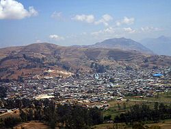
 View of Celendín from the top of Jelig | |
 Location of Celendín in the Cajamarca Region | |
| Country | Peru |
| Region | Cajamarca |
| Founded | September 30, 1862 |
| Capital | Celendín |
| Government | |
| • Mayor | José Ermitaño Marín Rojas |
| Area | |
• Total | 2,641.59 km2 (1,019.92 sq mi) |
| Elevation | 2,620 m (8,600 ft) |
| Population | |
• Total | 79,084 |
| • Density | 30/km2 (78/sq mi) |
| UBIGEO | 0603 |
| Website | www.municelendin.gob.pe |
Celendín is a province of the Cajamarca Region in Peru. The capital of the province is the city of Celendín.
Political division
[edit]The province measures 2,641.59 square kilometres (1,019.92 sq mi) and is divided into twelve districts:
| District | Mayor | Capital |
|---|---|---|
| Celendín | Juan De Dios Tello Villanueva | Celendín |
| Chumuch | Miller Enrique Pinedo Cepeda | Chumuch |
| Cortegana | Jose Marcial Castañeda Pereyra | Chimuch |
| Huasmín | Jose Ermitaño Marin Rojas | Huasmín |
| Jorge Chávez | Deyner Araujo Chavez | Lucmapampa |
| José Gálvez | Neiser Fernando Chavez Chavez | Huacapampa |
| La Libertad de Pallán | José Visitación Mego Cachay | La Libertad de Pallán |
| Miguel Iglesias | Flavio Ediver Davila Guevara | Chalán, Peru |
| Oxamarca | Gilberto Pajares Martos | Oxamarca |
| Sorochuco | Marcial Villanueva Izquierdo | Sorochuco |
| Sucre | Gerardo Romulo Machuca Aguilar | Sucre |
| Utco | Oscar Mercedes Campos Diaz | Utco |
See also
[edit]References
[edit]- (in Spanish) Provincia de Celendín es:Provincia de Celendín. Wikipedia en español, información bastante completa.
- (in Spanish) Instituto Nacional de Estadística e Informática. Banco de Información Digital. Retrieved November 4, 2007.
External links
[edit]- (in Spanish) Official province web site
6°52′00″S 78°08′29″W / 6.866647°S 78.141417°W


