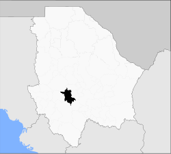
Carichí Municipality
Appearance
Carichí | |
|---|---|
 Municipality of Carichí in Chihuahua | |
| Coordinates: 27°55′N 107°03′W / 27.917°N 107.050°W | |
| Country | |
| State | Chihuahua |
| Municipal seat | Carichí |
| Area | |
• Total | 2,782 km2 (1,074 sq mi) |
| Population (2010) | |
• Total | 8,795 |
Carichí is one of the 67 municipalities of Chihuahua, in northern Mexico. The municipal seat lies at Carichí. The municipality covers an area of 2,782 km2.
As of 2010, the municipality had a total population of 8,795,[1] up from 7,944 as of 2005.[2]
As of 2010, the town of Carichí had a population of 1,672.[1] Other than the town of Carichí, the municipality had 315 localities, none of which had a population over 1,000.[1]
Geography
[edit]Towns and villages
[edit]| Village | Population (2005) |
|---|---|
| Total Municipality | 8,377 |
| Carichí | 1,478 |
| Ciénega de Ojos Azules | 649 |
| Tajirachi | 342 |
References
[edit]- ^ a b c "Carichí". Catálogo de Localidades. Secretaría de Desarrollo Social (SEDESOL). Archived from the original on 5 March 2016. Retrieved 23 April 2014.
- ^ "Carichí". Enciclopedia de los Municipios de México. Instituto Nacional para el Federalismo y el Desarrollo Municipal. Archived from the original on February 23, 2007. Retrieved August 22, 2008.


