Breakneck Pond
Appearance
| Breakneck Pond | |
|---|---|
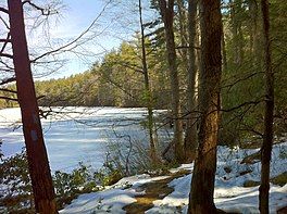
 Southern Breakneck Pond on Nipmuck Trail facing north on the last day of winter. | |
| Location | Tolland County, Connecticut |
| Coordinates | 42°01′17″N 72°06′36″W / 42.021356°N 72.109986°W |
| Type | lake |
| Surface area | 92 acres (0.37 km2) |
| Max. depth | 12 ft (3.7 m) |
Breakneck Pond is a 92-acre (0.37 km2)[1] lake surrounded by the Nipmuck State Forest in Union, Connecticut. A small portion of the lake extends into Sturbridge, Massachusetts. The maximum depth of the lake is 12 feet (3.7 m).[2] The entire lake shore is undeveloped and motorized vehicles and boats are prohibited. The lake is accessible through trails from Bigelow Hollow State Park and camping is permitted at three locations around the lake.[3][4] It is also the northern terminus for the Nipmuck Trail.
References
[edit]- ^ "Breakneck Pond Fishing".
- ^ "Archived copy" (PDF). Archived from the original (PDF) on December 22, 2015. Retrieved December 21, 2015.
{{cite web}}: CS1 maint: archived copy as title (link) - ^ "Archived copy" (PDF). Archived from the original (PDF) on October 21, 2012. Retrieved June 1, 2012.
{{cite web}}: CS1 maint: archived copy as title (link) - ^ "Archived copy" (PDF). Archived from the original (PDF) on August 10, 2011. Retrieved June 1, 2012.
{{cite web}}: CS1 maint: archived copy as title (link)
External links
[edit]

