Brantley Historic District
Appearance
Brantley Historic District | |
 | |
| Location | Roughly bounded by Sasser St, Fulton Ave., Peachtree St. and Wyatt, and the former Central of Georgia railroad line, Brantley, Alabama |
|---|---|
| Coordinates | 31°34′57″N 86°15′26″W / 31.5824°N 86.2572°W |
| Area | 48.8 acres (19.7 ha) |
| Built by | Harrington, Bill; Wyatt, Buster |
| Architectural style | Queen Anne, Bungalow/craftsman |
| NRHP reference No. | 04000558[1] |
| Added to NRHP | June 2, 2004 |
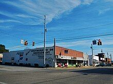
The Brantley Historic District in Brantley in Crenshaw County, Alabama, United States, is a 48.8 acres (19.7 ha) historic district which was listed on the National Register of Historic Places in 2004. It then included 112 contributing buildings and 15 non-contributing ones.[1][2]

The district is roughly bounded by Sasser St., Fulton Ave., Peachtree St. and Wyatt, and the former Central of Georgia railroad line.[2]
The town came into being in 1890 with the surveying of the railroad line.[2]
The district includes commercial buildings, and it also includes residences, including Victorian cottages built along both sides of Main Street by carpenters Buster Wyatt and Bill Harrington.[2]
References
[edit]- ^ a b "National Register Information System". National Register of Historic Places. National Park Service. July 9, 2010.
- ^ a b c d Gene A. Ford, Linda Ford, Christy Anderson (August 2001). "National Register of Historic Places Registration: Brantley Historic District". National Park Service. Retrieved August 15, 2017.
{{cite web}}: CS1 maint: multiple names: authors list (link) With photos.
External links
[edit] Media related to Brantley Historic District at Wikimedia Commons


