Bowerre
Appearance
This article relies largely or entirely on a single source. (November 2024) |
You can help expand this article with text translated from the corresponding article in German. (October 2011) Click [show] for important translation instructions.
|
| Bowerre | |
|---|---|
 | |
 | |
| Location | |
| Country | Germany |
| State | North Rhine-Westphalia |
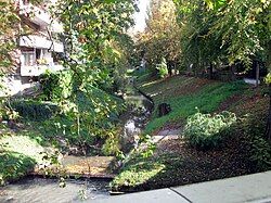
The Bowerre is a former branch of the river Werre in the centre of the town of Herford, North Rhine-Westphalia, Germany. The Bowerre formed the border between the Altstadt ("old town") and Neustadt ("new town") until the 1960s.
It was the site of a linen mill from the 13th century until 1972, when the old course of the Werre was filled in, partly due to poor water quality.[1] Filling in the Bowerre was controversial at the time, and later caused the groundwater level to sink in the town, which still causes ground instability today.[1]
See also
[edit]References
[edit]- ^ a b "Linnenbauerplatz". entdecke.dein-nrw.de. Touristikgemeinschaft Wittekindsland Herford e.V. Retrieved 29 November 2024.
52°07′04″N 8°40′04″E / 52.11778°N 8.66778°E
