Bessang Pass Natural Monument
| Bessang Pass Natural Monument | |
|---|---|
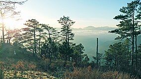
 View from the summit of Mount Namandiraan at the Bessang Pass Natural Monument | |
| Location | Ilocos Sur, Philippines |
| Nearest city | Candon |
| Coordinates | 16°57′37″N 120°39′28″E / 16.96028°N 120.65778°E |
| Area | 693.32 hectares (1,713.2 acres) |
| Established | August 10, 1954 (National shrine) April 23, 2000 (Natural monument) |
| Governing body | Department of Environment and Natural Resources |
The Bessang Pass Natural Monument is a protected area and memorial that commemorates the victory on June 14, 1945, by Filipino soldiers serving the U.S. Army Forces in the Philippines Northern Luzon (USAFIP-NL) over the Imperial Japanese Army in the Battle of Bessang Pass which led to Japan's eventual surrender and end to World War II in the Philippines. It covers an area of 693.32 hectares (1,713.2 acres) and a buffer zone of 427.79 hectares (1,057.1 acres) in the municipality of Cervantes in Ilocos Sur.[1] The mountain pass was initially a component of the Tirad Pass National Park, declared in 1938 through Proclamation No. 294 by then President Manuel Luis Quezon. On August 10, 1954, it was established as the Bessang Pass National Shrine with an area of 304 hectares (750 acres) by virtue of Proclamation No. 55 signed by President Ramon Magsaysay.[2] The national shrine was finally declared and reclassified as a natural monument under the National Integrated Protected Areas System in April 2000 through Proclamation No. 284 by President Joseph Estrada.[3]

Description
[edit]Bessang Pass lies along Route 4, which is now known as the Tagudin–Cervantes–Sabangan Road (N205) in the barangay of Malaya.[4]: 549 The pass lies on the southeast side of Langiatan Hill, which reaches a height of 4,000 feet (1,200 m).[4]: 550 South of the pass, Mount Namogoian rises to 6,830 feet (2,080 m).[4]: 550 East of Langiatan Hill is Magun Hill at 4,500 feet (1,400 m).[4]: 550
The park contains pine forests as well as mossy type forests. It is crossed by the Bessang Creek and Matukbo River which provides the water supply for Cervantes and other surrounding communities.[5] The park is also the habitat of 29 bird species, 5 mammals, and reptiles such as the monitor lizard and different species of snakes.[5]
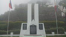
A monument honoring the 1,395 USAFIP-NL members killed during the battle was unveiled in the park in 1954.[6]
See also
[edit]- Luzon tropical pine forests
- MacArthur Landing Memorial National Park
- Northern Luzon Heroes Hill National Park
References
[edit]- ^ "Region 1 - Protected Areas". Department of Environment and Natural Resources Biodiversity Management Bureau. Archived from the original on November 8, 2014. Retrieved November 8, 2014.
- ^ "Proclamation No. 55, s. 1954". Official Gazette of the Republic of the Philippines. Retrieved November 8, 2014.
- ^ "Proclamation No. 284" (PDF). Department of Environment and Natural Resources. Archived from the original (PDF) on November 8, 2014. Retrieved November 8, 2014.
- ^ a b c d Smith, R.R., 2005, Triumph in the Philippines, Honolulu: University Press of the Pacific, ISBN 1410224953
- ^ a b "Senate Bill No. 2143" (PDF). Senate of the Philippines. Archived from the original (PDF) on September 24, 2015. Retrieved November 8, 2014.
- ^ "About Us". Municipal Government of Cervantes. Archived from the original on November 8, 2014. Retrieved November 8, 2014.


