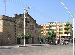
Bermejo, Bolivia
Appearance
Bermejo | |
|---|---|
City | |
| Nickname: "Capital Petrolera de Bolivia" | |
| Coordinates: 22°43′56″S 64°20′33″W / 22.73222°S 64.34250°W | |
| Country | |
| Department | Tarija Department |
| Province | Ancieto Arce |
| Elevation | 609 m (1,998 ft) |
| Population (2012) | |
• Total | 35,411 |
| Time zone | UTC-4 (BOT) |
Bermejo is a city in Bolivia, south of the Tariquía Flora and Fauna National Reserve. It is in a broad, open valley of the Cordillera Central range that extends southward into Argentina, and is on the Bermejo River, locally the border between Bolivia and Argentina.[1][2]
It is served by Bermejo Airport.
-
Colonial church in Bermejo
-
Bermejo River
Climate
[edit]| Climate data for Bermejo (Bermejo Airport), elevation 385 m (1,263 ft) | |||||||||||||
|---|---|---|---|---|---|---|---|---|---|---|---|---|---|
| Month | Jan | Feb | Mar | Apr | May | Jun | Jul | Aug | Sep | Oct | Nov | Dec | Year |
| Mean daily maximum °C (°F) | 33.2 (91.8) |
32.2 (90.0) |
30.3 (86.5) |
27.0 (80.6) |
23.9 (75.0) |
21.4 (70.5) |
22.7 (72.9) |
25.7 (78.3) |
29.3 (84.7) |
32.4 (90.3) |
32.5 (90.5) |
33.5 (92.3) |
28.7 (83.6) |
| Daily mean °C (°F) | 27.1 (80.8) |
26.4 (79.5) |
24.9 (76.8) |
22.1 (71.8) |
18.9 (66.0) |
16.0 (60.8) |
16.0 (60.8) |
18.2 (64.8) |
21.3 (70.3) |
25.0 (77.0) |
25.8 (78.4) |
27.0 (80.6) |
22.4 (72.3) |
| Mean daily minimum °C (°F) | 20.9 (69.6) |
20.6 (69.1) |
19.6 (67.3) |
17.2 (63.0) |
13.9 (57.0) |
10.6 (51.1) |
9.4 (48.9) |
10.7 (51.3) |
13.4 (56.1) |
17.7 (63.9) |
19.2 (66.6) |
20.6 (69.1) |
16.2 (61.1) |
| Average precipitation mm (inches) | 199.8 (7.87) |
197.6 (7.78) |
179.3 (7.06) |
96.0 (3.78) |
29.0 (1.14) |
13.8 (0.54) |
12.7 (0.50) |
5.4 (0.21) |
16.5 (0.65) |
59.6 (2.35) |
108.5 (4.27) |
179.9 (7.08) |
1,098.1 (43.23) |
| Average precipitation days | 11.0 | 10.3 | 11.3 | 9.6 | 5.1 | 3.9 | 2.5 | 1.6 | 2.2 | 5.6 | 8.1 | 9.9 | 81.1 |
| Average relative humidity (%) | 73.7 | 77.4 | 80.4 | 82.0 | 79.8 | 80.1 | 74.2 | 67.2 | 61.1 | 62.6 | 67.3 | 70.6 | 73.0 |
| Source: Servicio Nacional de Meteorología e Hidrología de Bolivia[3][4] | |||||||||||||
References
[edit]- ^ "Google Maps". Google Maps. Retrieved 25 April 2016.
- ^ OpenStreetMap - Bermejo
- ^ "Base de datos Sistema Meteorológico–SISMET" (in Spanish). Servicio Nacional de Meteorología e Hidrología de Bolivia. Archived from the original on 7 June 2018. Retrieved 12 June 2024.
- ^ "índices climáticos para 149 estaciones meteorológicas en Bolivia" (in Spanish). Servicio Nacional de Meteorología e Hidrología de Bolivia. Retrieved 12 June 2024.
External links
[edit]- Account of a trip to the city of Bermejo in 2016 (in Spanish)


