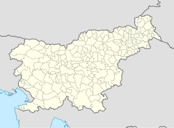
Berkovci
Appearance
Berkovci
Berkovci pri Prosenjakovcih (after 1955), Berkeháza | |
|---|---|
| Coordinates: 46°45′7.98″N 16°17′32.39″E / 46.7522167°N 16.2923306°E | |
| Country | |
| Traditional region | Prekmurje |
| Statistical region | Mura |
| Municipality | Moravske Toplice |
| Area | |
• Total | 1.62 km2 (0.63 sq mi) |
| Elevation | 249.4 m (818.2 ft) |
| Population (2002) | |
• Total | 55 |
| [1] | |
Berkovci (pronounced [ˈbeːɾkɔu̯tsi]; Hungarian: Berkeháza) is a settlement northwest of Prosenjakovci in the Municipality of Moravske Toplice in the Prekmurje region of Slovenia.[2]
There is a small chapel in the settlement with a three-story belfry. It was built in 1913.[3]
Name
[edit]The name of the settlement was changed from Berkovci to Berkovci pri Prosenjakovcih in 1955.[4][5] The name was later shortened to Berkovci.[6]
References
[edit]- ^ Statistical Office of the Republic of Slovenia
- ^ Moravske Toplice municipal site
- ^ Slovenian Ministry of Culture register national heritage reference number 22029
- ^ Spremembe naselij 1948–95. 1996. Database. Ljubljana: Geografski inštitut ZRC SAZU, DZS.
- ^ "Zakon o območjih okrajev in občin v Ljudski republiki Sloveniji". Uradni list Ljudske republike Slovenije. 12 (24): 502. June 30, 1955. Retrieved August 1, 2024.
- ^ Statistical Office of the Republic of Slovenia. Berkovci. (in Slovene)
External links
[edit]


