Bears, Friesland
Beers
Bears | |
|---|---|
Village | |
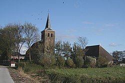
 St Mary's church | |
 | |
 Bears in the former municipality of Littenseradiel | |
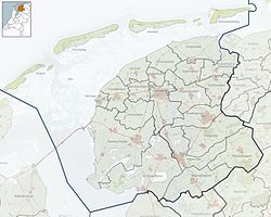
| Coordinates: 53°9′23″N 5°44′2″E / 53.15639°N 5.73389°E | |
| Country | |
| Province | |
| Municipality | |
| Area | |
• Total | 2.46 km2 (0.95 sq mi) |
| Elevation | 2 m (7 ft) |
| Population (2021)[1] | |
• Total | 135 |
| • Density | 55/km2 (140/sq mi) |
| Time zone | UTC+1 (CET) |
| • Summer (DST) | UTC+2 (CEST) |
| Postal code | 9025[1] |
| Dialing code | 058 |
Bears (Dutch: Beers) is a small village in the Dutch province of Friesland.[3] It is located in the municipality Leeuwarden, about 8 km southwest of Leeuwarden.[4] Bears has a population of about 133 in January 2017.[5]
The official name of the village is in Frisian ("Bears"), like all villages in Littenseradiel. "Beers" is the Dutch name.
History
[edit]It was first mentioned in 1305 as Beerse, and means "fenced off hunting area".[6] Bears is a terp (artificial living hill) village. The Protestant church of Bears dates from the 13th century.[7] The Uniastate was a stins of the Unia family. The estate was demolished in 1756, and only the gate house has remained. A steel framed replica of the estate was built in the 1990, and has an observation tower in the middle to view the landscape.[8]
Before 2018, the village was part of the Littenseradiel municipality.[7]
Notable buildings
[edit]Gallery
[edit]-
Sculpture of the former Uniastate
-
View on Bears
-
Inside the Maria Church
-
Gate house of Uniastate
References
[edit]- ^ a b c "Kerncijfers wijken en buurten 2021". Central Bureau of Statistics. Retrieved 30 March 2022.
- ^ "Postcodetool for 9025BL". Actueel Hoogtebestand Nederland (in Dutch). Het Waterschapshuis. Retrieved 30 March 2022.
- ^ VUGA's Alfabetische Plaatsnamengids van Nederland (13th edition), VUGA, 1997.
- ^ ANWB Topografische Atlas Nederland, Topografische Dienst and ANWB, 2005.
- ^ Aantal inwoners per dorp Archived 2017-04-21 at the Wayback Machine - Littenseradiel
- ^ "Beers - (geografische naam)". Etymologiebank (in Dutch). Retrieved 30 March 2022.
- ^ a b "Bears". Plaatsengids (in Dutch). Retrieved 30 March 2022.
- ^ "Uniastate en Tsjerke Bears". Friesland (in Dutch). Retrieved 30 March 2022.
External links
[edit] Media related to Bears (Friesland) at Wikimedia Commons


