Bandar-e Anzali County
Bandar-e Anzali County
Persian: شهرستان بندر انزلی | |
|---|---|
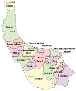
 Location of Bandar-e Anzali County in Gilan province (top center, green) | |
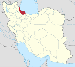
 Location of Gilan province in Iran | |
| Coordinates: 37°28′31″N 49°26′30″E / 37.47528°N 49.44167°E[1] | |
| Country | |
| Province | Gilan |
| Capital | Bandar-e Anzali |
| Districts | Central |
| Population (2016)[2] | |
• Total | 139,016 |
| Time zone | UTC+3:30 (IRST) |
| Bandar-e Anzali County can be found at GEOnet Names Server, at this link, by opening the Advanced Search box, entering "9206999" in the "Unique Feature Id" form, and clicking on "Search Database". | |
Bandar-e Anzali County (Persian: شهرستان بندر انزلی)[a] is in Gilan province, in northwestern Iran. Its capital is the city of Bandar-e Anzali.[4][b]
Bandar Anzali County is bordered by the Caspian Sea on the north, Sowme'eh Sara County on the south, Khomam County on the east, Rasht County on the southeast, and Rezvanshahr County on the west.
Demographics
[edit]Population
[edit]At the time of the 2006 National Census, the county's population was 130,851 in 38,810 households.[5] The following census in 2011 counted 138,004 people in 45,080 households.[6] The 2016 census measured the population of the county as 139,016 in 48,193 households.[2]
Administrative divisions
[edit]Bandar-e Anzali County's population history and administrative structure over three consecutive censuses are shown in the following table.
| Administrative Divisions | 2006[5] | 2011[6] | 2016[2] |
|---|---|---|---|
| Central District | 130,851 | 138,001 | 139,015 |
| Chahar Farizeh RD | 13,829 | 12,960 | 12,207 |
| Licharegi-ye Hasan Rud RD | 7,335 | 8,377 | 8,244 |
| Bandar-e Anzali (city) | 109,687 | 116,664 | 118,564 |
| Total | 130,851 | 138,004 | 139,016 |
| RD = Rural District | |||
See also
[edit]![]() Media related to Bandar-e Anzali County at Wikimedia Commons
Media related to Bandar-e Anzali County at Wikimedia Commons
Notes
[edit]- ^ Formerly Bandar-e Pahlavi County (شهرستان بندر پهلوی)[3]
- ^ Formerly Bandar-e Pahlavi[3]
References
[edit]- ^ OpenStreetMap contributors (12 October 2024). "Bandar-e Anzali County" (Map). OpenStreetMap (in Persian). Retrieved 12 October 2024.
- ^ a b c Census of the Islamic Republic of Iran, 1395 (2016): Gilan Province. amar.org.ir (Report) (in Persian). The Statistical Center of Iran. Archived from the original (Excel) on 4 December 2020. Retrieved 19 December 2022.
- ^ a b Bazargan, Mehdi (c. 2023) [Approved 12 June 1358]. Changing the name of the city and county of Bandar Pahlavi to Bandar-e Anzali. lamtakam.com (Report) (in Persian). Ministry of the Interior, Council of Ministers of the Provisional Government of the Islamic Republic of Iran. Proposal 7473.53. Archived from the original on 13 December 2023. Retrieved 13 December 2023 – via Lam ta Kam.
- ^ Habibi, Hassan (21 October 2015) [Approved 21 June 1369]. Approval of the organization and chain of citizenship of the elements and units of the national divisions of Gilan province centered on the city of Rasht. rc.majlis.ir (Report) (in Persian). Ministry of the Interior, Defense Political Commission of the Government Board. Proposal 3233.1.5.53; Notification 82846/T135K. Archived from the original on 12 October 2016. Retrieved 12 December 2023 – via Islamic Parliament Research Center.
- ^ a b Census of the Islamic Republic of Iran, 1385 (2006): Gilan Province. amar.org.ir (Report) (in Persian). The Statistical Center of Iran. Archived from the original (Excel) on 20 September 2011. Retrieved 25 September 2022.
- ^ a b Census of the Islamic Republic of Iran, 1390 (2011): Gilan Province. irandataportal.syr.edu (Report) (in Persian). The Statistical Center of Iran. Archived from the original (Excel) on 8 October 2023. Retrieved 19 December 2022 – via Iran Data Portal, Syracuse University.

