Bakonytamási
Appearance
Bakonytamási | |
|---|---|
 | |
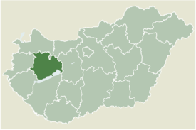
 Location of Veszprém county in Hungary | |
| Coordinates: 47°24′44″N 17°43′57″E / 47.41232°N 17.73246°E | |
| Country | |
| County | Veszprém |
| Area | |
• Total | 20.49 km2 (7.91 sq mi) |
| Population (2004) | |
• Total | 691 |
| • Density | 33.72/km2 (87.3/sq mi) |
| Time zone | UTC+1 (CET) |
| • Summer (DST) | UTC+2 (CEST) |
| Postal code | 8555 |
| Area code | 89 |
Bakonytamási (Hungarian pronunciation: [ˈbɒkoɲtɒmaːʃi]) is a village in Veszprém county, Hungary.
In the 19th and 20th centuries, a small Jewish community lived in the village, in 1910 35 Jews lived in the village,[1] most of whom were murdered in the Holocaust.[2] The community had a Jewish cemetery.[3]
References
[edit]External links
[edit]


