Aninoasa, Argeș
Appearance
Aninoasa | |
|---|---|
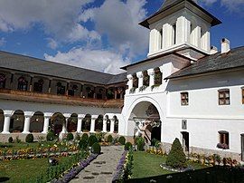
 Aninoasa Monastery | |
| Coordinates: 45°11′39.4″N 24°55′41.3″E / 45.194278°N 24.928139°E | |
| Country | Romania |
| County | Argeș |
| Government | |
| • Mayor (2021–2024) | Nicolae-Marius Manole[1] (PSD) |
Area | 57.57 km2 (22.23 sq mi) |
| Elevation | 161 m (528 ft) |
| Population (2021-12-01)[2] | 3,190 |
| • Density | 55/km2 (140/sq mi) |
| Time zone | EET/EEST (UTC+2/+3) |
| Vehicle reg. | AG |
| Website | comuna-aninoasa |
Aninoasa is a commune in Argeș County, Muntenia, Romania. It is composed of four villages: Aninoasa, Broșteni, Slănic and Valea Siliștii.
The commune is located in the north-central part of the county. It is crossed by the DN73C road that connects Câmpulung (20 km (12 mi) to the northeast) to Curtea de Argeș (35 km (22 mi) to the west). The river Bratia passes through the Aninoasa and Valea Siliștii villages.
The Aninoasa Monastery (dating from 1678) is situated on the territory of the commune.
References
[edit]- ^ "Results of the 2021 local elections". Central Electoral Bureau. Retrieved 30 June 2021.
- ^ "Populaţia rezidentă după grupa de vârstă, pe județe și municipii, orașe, comune, la 1 decembrie 2021" (XLS). National Institute of Statistics.


