Čechtice
Čechtice | |
|---|---|
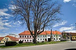
 Centre of Čechtice | |
| Coordinates: 49°37′27″N 15°2′54″E / 49.62417°N 15.04833°E | |
| Country | |
| Region | Central Bohemian |
| District | Benešov |
| First mentioned | 1315 |
| Area | |
• Total | 39.41 km2 (15.22 sq mi) |
| Elevation | 478 m (1,568 ft) |
| Population (2024-01-01)[1] | |
• Total | 1,453 |
| • Density | 37/km2 (95/sq mi) |
| Time zone | UTC+1 (CET) |
| • Summer (DST) | UTC+2 (CEST) |
| Postal code | 257 65 |
| Website | www |
Čechtice is a market town in Benešov District in the Central Bohemian Region of the Czech Republic. It has about 1,500 inhabitants.
Administrative parts
[edit]The villages of Černičí, Dobříkovice, Jeníkov, Krčmy, Malá Paseka, Nakvasovice, Nové Práchňany, Otročice, Palčice, Růžkovy Lhotice, Staré Práchňany, Sudislavice and Zhoř are administrative parts of Čechtice.
Etymology
[edit]The name is derived from the personal name Čechta, meaning "the village of Čechta's people".[2]
Geography
[edit]Čechtice is located about 31 kilometres (19 mi) southeast of Benešov and 60 km (37 mi) southeast of Prague. It lies in the Křemešník Highlands. The highest point is the hill Zhoř at 626 m (2,054 ft) above sea level.
History
[edit]The first written mention of Čechtice is from 1315.[3] The greatest prosperity occurred in the 16th century, during the rule of the Střela of Rokyce family. As a result, Čechtice was promoted to a market town in 1592.[4] The properties of the family were confiscated in 1622 after the Battle of White Mountain.[5]
After the Battle of White Mountain, Čechtice were acquired by the Halleweil family. They had built here a castle. The next notable owner of the estate was John Leopold of Trautson and Falkenstein, who bought it in 1702. He restored the local school and moved the administration of the estate from Křivsoudov to Čechtice.[4][5]
Demographics
[edit]
|
|
| ||||||||||||||||||||||||||||||||||||||||||||||||||||||
| Source: Censuses[6][7] | ||||||||||||||||||||||||||||||||||||||||||||||||||||||||
Transport
[edit]There are no railways or major roads passing through the municipal territory.
Sights
[edit]
The Čechtice Castle is a Baroque castle built in 1656–1658. Its north wing was never completed, but the west wing was extended at the end of the 17th century. Today it is a hotel.[8]
The Church of Saint James the Great was originally a Gothic church from the 14th century. After it was badly damaged by fires in 1741 and 1792, it was rebuilt in the Baroque style.[9]
In Růžkovy Lhotice is the Růžkovy Lhotice Castle. It is a late Baroque building from the second half of the 18th century. Today it houses the regional museum.[10]
References
[edit]- ^ "Population of Municipalities – 1 January 2024". Czech Statistical Office. 2024-05-17.
- ^ Profous, Antonín (1947). Místní jména v Čechách I: A–H (in Czech). pp. 305–306.
- ^ "Úvod do historie" (in Czech). Městys Čechtice. Retrieved 2023-03-07.
- ^ a b "Čechtický hrabě byl boháč, zlato prý ukryl do sudů" (in Czech). Deník.cz. 2010-04-27. Retrieved 2023-03-07.
- ^ a b "Historický vývoj" (in Czech). Městys Křivsoudov. Retrieved 2023-03-07.
- ^ "Historický lexikon obcí České republiky 1869–2011" (in Czech). Czech Statistical Office. 2015-12-21.
- ^ "Population Census 2021: Population by sex". Public Database. Czech Statistical Office. 2021-03-27.
- ^ "Zámek" (in Czech). National Heritage Institute. Retrieved 2023-03-07.
- ^ "Podrobná historie" (in Czech). Farnost Čechtice. Retrieved 2023-03-07.
- ^ "Zámek" (in Czech). National Heritage Institute. Retrieved 2023-11-06.


