Žarnovica
Žarnovica
Zsarnóca | |
|---|---|
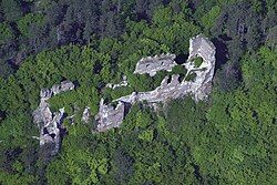
 Ruins of castle Revište in municipal district Revištské Podzámčie | |
Location of Žarnovica in the Banská Bystrica Region Location of Žarnovica in Slovakia | |
| Coordinates: 48°29′N 18°43′E / 48.48°N 18.72°E | |
| Country | |
| Region | |
| District | Žarnovica District |
| First mentioned | 1332 |
| Government | |
| • Mayor | Alena Kazimírová |
| Area | |
• Total | 30.40 km2 (11.74 sq mi) |
| Elevation | 252 m (827 ft) |
| Population (2021)[3] | |
• Total | 5,699 |
| Time zone | UTC+1 (CET) |
| • Summer (DST) | UTC+2 (CEST) |
| Postal code | 966 81[2] |
| Area code | +421 45[2] |
| Car plate | ZC |
| Website | www |
Žarnovica (German: Scharnowitz; Hungarian: Zsarnóca) is a town and municipality in the Žarnovica District, Banská Bystrica Region in Slovakia. The town is situated in the Hron river valley. It has a population of around 6,000 people.
History
[edit]The first written mention about Žarnovica is dated to 1332.
Geography
[edit]Žarnovica lies at an altitude of 230 metres (755 ft) above sea level and covers an area of 30.4 square kilometres (11.7 sq mi).[4] It is located in the Žiar Basin in central Slovakia, on the Hron River, between Vtáčnik and Štiavnické vrchy mountain ranges.
Demographics
[edit]| Year | Pop. | ±% |
|---|---|---|
| 1970 | 4,030 | — |
| 1980 | 4,669 | +15.9% |
| 1991 | 6,532 | +39.9% |
| 2001 | 6,596 | +1.0% |
| 2011 | 6,490 | −1.6% |
| 2021 | 5,830 | −10.2% |
| Source: Censuses[5][6] | ||
According to the 2001 census, the town had 6,596 inhabitants. 95.59% of inhabitants were Slovaks, 1.61% Roma and 0.73% Czechs. The religious make-up was 78.73% Roman Catholics, 15.25% people with no religious affiliation and 1.32% Lutherans.[4]
Sport
[edit]- Speedway Žarnovica is a motorcycle speedway venue in the centre of the town. It hosts major international events.[7]
References
[edit]- ^ "Hustota obyvateľstva - obce [om7014rr_ukaz: Rozloha (Štvorcový meter)]". www.statistics.sk (in Slovak). Statistical Office of the Slovak Republic. 2022-03-31. Retrieved 2022-03-31.
- ^ a b c "Základná charakteristika". www.statistics.sk (in Slovak). Statistical Office of the Slovak Republic. 2015-04-17. Retrieved 2022-03-31.
- ^ "Počet obyvateľov podľa pohlavia - obce (ročne)". www.statistics.sk (in Slovak). Statistical Office of the Slovak Republic. 2022-03-31. Retrieved 2022-03-31.
- ^ a b "Municipal Statistics". Statistical Office of the Slovak Republic. Archived from the original on 2008-01-11. Retrieved 2008-01-26.
- ^ "Statistical lexikon of municipalities 1970-2011" (PDF) (in Slovak).
- ^ "Census 2021 - Population - Basic results". Statistical Office of the Slovak Republic. 2021-01-01.
- ^ "Individual Speedway European Championship Challenge in Zarnovica (Slovakia)" (PDF). FIM. Retrieved 4 February 2024.
External links
[edit]- Municipal website (in Slovak)


