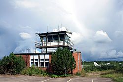
Ylivieska Airfield
Appearance
Ylivieska Airfield Ylivieskan lentokenttä | |||||||||||
|---|---|---|---|---|---|---|---|---|---|---|---|
 | |||||||||||
| Summary | |||||||||||
| Operator | Town of Ylivieska | ||||||||||
| Location | Ylivieska, Finland | ||||||||||
| Elevation AMSL | 252 ft / 77 m | ||||||||||
| Coordinates | 64°03′17″N 024°43′31″E / 64.05472°N 24.72528°E | ||||||||||
| Website | www.ylivieska.fi/... | ||||||||||
| Map | |||||||||||
 | |||||||||||
| Runways | |||||||||||
| |||||||||||
Source: VFR Finland[1] | |||||||||||
Ylivieska Airfield (IATA: YLI[2], ICAO: EFYL) is an aerodrome located in Vähäkangas, Ylivieska, Finland, about 10 kilometres (6 mi) east-southeast of Ylivieska town centre.[1]
The airfield was opened in 1982, and it replaced the old airfield in Niemenkylä.[3] The airport had commercial service until 1996, and the runway was ILS equipped prior to the aerodrome's relegation to uncontrolled status in late 2003.[4]
See also
[edit]References
[edit]- ^ a b "Ylivieska, Finland – EFYL". VFR Suomi / Finland. Vantaa: Finavia. 18 November 2010. Retrieved 26 August 2011.
- ^ Accident history for YLI/EFYL at Aviation Safety Network
- ^ "Historiikki" [History] (in Finnish). Kalajokilaakson Ilmailukerho ry. 15 April 2010. Retrieved 2011-08-26.
- ^ EFYL – Ylivieska. AIP Suomi/Finland, 15.6.2000, s. EFYL AD 2.1, 1–10. Vantaa: Ilmailulaitos.
External links
[edit]- Town of Yliviska – Ylivieska Airfield (in Finnish)
- VFR Suomi/Finland – Ylivieska Airfield
- Lentopaikat.net – Ylivieska Airfield (in Finnish)

