Western Greece
Western Greece
Περιφέρεια Δυτικής Ελλάδας | |
|---|---|
 | |
| Coordinates: 38°12′N 21°24′E / 38.2°N 21.4°E | |
| Country | |
| Decentralized Administration | Peloponnese, Western Greece and the Ionian |
| Capital and largest city | Patras |
| Regional units | |
| Government | |
| • Regional governor | Nektarios Farmakis (New Democracy) |
| Area | |
• Total | 11,350.18 km2 (4,382.33 sq mi) |
| Population (2021)[1] | |
• Total | 648,220 |
| • Density | 57/km2 (150/sq mi) |
| Time zone | UTC+2 (EET) |
| • Summer (DST) | UTC+3 (EEST) |
| ISO 3166 code | GR-G |
| HDI (2022) | 0.864[2] very high · 12th of 13 |
| Website | www |
Western Greece Region (Greek: Περιφέρεια Δυτικής Ελλάδας, romanized: Periféria Dhitikís Elládhas, [periˈferia ðitiˈcis eˈlaðas])[3] is one of the thirteen administrative regions of Greece. It comprises the western part of continental Greece and the northwestern part of the Peloponnese peninsula. It occupies an area of 11,336 km2 (4,377 sq mi) and its population is, according to the 2011 census, at 679,796 inhabitants.[4][5] The capital of the Western Greece is Patras, the third-largest-city in the country with a population of about 280,000 inhabitants. The NUTS 2 code for the region of Western Greece is EL63.[6]
Administration
[edit]The region of Western Greece was established in the 1987 administrative reform.[7] With the 2010 Kallikratis plan, its powers and authority were redefined and extended. Along with Peloponnese and the Ionian Islands regions, it is supervised by the Decentralized Administration of Peloponnese, Western Greece and the Ionian Islands based at Patras. The region is based at Patras and is divided into three regional units (pre-Kallikratis prefectures), Aetolia-Acarnania in Central Greece and Achaea and Elis in Peloponnese, which are further subdivided into 19 municipalities.
Climate
[edit]The region has hot, dry summers and mild, wet winters, typical of a Mediterranean climate (Csa). Sunny days dominate during the summer months in areas within the beaches and partially cloudy and rainy in the mountains. Snow is very common during the winter in the mountains of Erymanthus, Panachaiko and Aroania. Winter average temperatures are around the 10 °C mark throughout the low-lying areas.
Economy
[edit]The Gross domestic product (GDP) of the region was 8.3 billion € in 2018, accounting for 4.5% of Greek economic output. GDP per capita adjusted for purchasing power was €15,200 or 50% of the EU27 average in the same year. The GDP per employee was 65% of the EU average.[8]
Demographics
[edit]The region has shrunk by 36,447 people between 2011 and 2021, experiencing a population loss of 5.4%.[1]
Major communities
[edit]- Agrinio (Αγρίνιο)
- Aigio (Αίγιο)
- Amaliada (Αμαλιάδα)
- Amfilochia (Αμφιλοχία)
- Archaia Olympia (Αρχαία Ολυμπία) or Olympia (Ολυμπία)
- Farres (Φαρρές)
- Gastouni (Γαστούνη)
- Kalavryta (Καλάβρυτα)
- Kato Achaia (Κάτω Αχαΐα)
- Messolonghi (Μεσολόγγι)
- Nafpaktos (Ναύπακτος)
- Patras (Πάτρα)
- Pyrgos (Πύργος)
- Vouprasia (Βουπρασία)
- Zacharo (Ζαχάρω)
Gallery
[edit]-
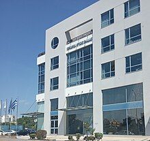
Region of Western Greece administrative building in Patras, Greece
References
[edit]- ^ a b "Census 2021 GR" (PDF) (Press release). Hellenic Statistical Authority. 2022-07-19. Retrieved 2022-09-12.
- ^ "Sub-national HDI - Area Database - Global Data Lab". hdi.globaldatalab.org. Retrieved 2021-07-20.
- ^ "Region of Western Greece" – via www.youtube.com.
- ^ "Region of Western Greece". www.interreg-balkanmed.eu. Retrieved 2022-01-27.
- ^ "Demographic and social characteristics of the Resident Population of Greece according to the 2011 Population - Housing Census revision of 20/3/2014" (PDF). Hellenic Statistical Authority. 12 September 2014.
- ^ Regions in the European Union, Nomenclature of territorial units for statistics - NUTS 2016/EU-28, 2018 Edition (pdf in English)
- ^ Π.Δ. 51/87 «Καθορισμός των Περιφερειών της Χώρας για το σχεδιασμό, προγραμματισμό και συντονισμό της Περιφερειακής Ανάπτυξης», (Official Government Gazette of Greece, no. 26A'/06-03-1987)
- ^ "Regional GDP per capita ranged from 30% to 263% of the EU average in 2018". Eurostat.
External links
[edit]- Official website
 (in Greek)


