Antrona Schieranco
Appearance
(Redirected from Valle d'Antrona)
Antrona Schieranco | |
|---|---|
| Comune di Antrona Schieranco | |
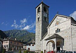
 Church of St. Lawrence (right) and the Town Hall (left) | |
| Coordinates: 46°4′N 8°7′E / 46.067°N 8.117°E | |
| Country | Italy |
| Region | Piedmont |
| Province | Verbano-Cusio-Ossola (VB) |
| Frazioni | Cheggio, Locasca, Madonna, Rovesca |
| Government | |
| • Mayor | Claudio Simona |
| Area | |
• Total | 100.7 km2 (38.9 sq mi) |
| Elevation | 902 m (2,959 ft) |
| Population | |
• Total | 529 |
| • Density | 5.3/km2 (14/sq mi) |
| Demonym | Antronesi |
| Time zone | UTC+1 (CET) |
| • Summer (DST) | UTC+2 (CEST) |
| Postal code | 28841 |
| Dialing code | 0324 |
| Website | Official website |
Antrona Schieranco is a comune (municipality) in the Province of Verbano-Cusio-Ossola in the Italian region Piedmont, located about 120 kilometres (75 mi) northeast of Turin and about 35 kilometres (22 mi) northwest of Verbania, in a branch of the Val d'Ossola, on the border with Switzerland.
Antrona Schieranco borders the following municipalities: Bognanco, Borgomezzavalle, Calasca-Castiglione, Ceppo Morelli, Montescheno, Saas Almagell (Switzerland), Vanzone con San Carlo, Zwischbergen (Switzerland). Until 1946, it was a center for silver and gold mining.
The Portjengrat (Italian: Pizzo d'Andolla) is located nearby.
References
[edit]- ^ "Superficie di Comuni Province e Regioni italiane al 9 ottobre 2011". Italian National Institute of Statistics. Retrieved 16 March 2019.
- ^ All demographics and other statistics: Italian statistical institute Istat.
- ^ "Popolazione Residente al 1° Gennaio 2018". Italian National Institute of Statistics. Retrieved 16 March 2019.


