User:Revolution Saga/sandbox/Armenian highlands
| Armenian highlands | |
|---|---|
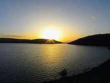
 The Armenian highlands near the Iran–Turkey border | |
| Highest point | |
| Peak | Mount Ararat, Turkey |
| Elevation | 5,137 m (16,854 ft) |
| Coordinates | 39°42′07″N 44°17′54″E / 39.7019°N 44.2983°E[1] |
| Dimensions | |
| Area | 400,000 km2 (150,000 sq mi) |
| Geography | |
| Countries | Armenia, Azerbaijan, Iran and Turkey |
| Region | Western Asia |
| Range coordinates | 39°17′01″N 43°22′19″E / 39.28361°N 43.37194°E |
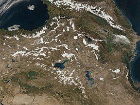
The Armenian highlands (Armenian: Հայկական լեռնաշխարհ, romanized: Haykakan lernashkharh), also known as the Armenian upland, Armenian plateau, or Armenian tableland,[2] is a plateau in West Asia. It is the most central and the highest of the three plateaus that together form the northern sector of West Asia.[2] Clockwise starting from the west, the Armenian highlands are bounded by the Anatolian plateau, the Caucasus, the Kura-Aras lowlands, the Iranian Plateau, and Mesopotamia.
Name
[edit]The term Armenian highlands was coined by the nineteenth-century German geologist Otto Wilhelm Hermann Abich.
Geography and topography
[edit]

The Armenian highlands is part of the Alpide belt, forming part of the Eurasian range that stretches from the Pontic Mountains to the Malay Peninsula. Its total area is about 400,000 km2.[3] Historically, the Armenian highlands have been the scene of great volcanic activity.[4] Geologically recent volcanism on the area has resulted in large volcanic formations and a series of massifs and tectonic movement has formed the three largest lakes in the Highlands; Lake Sevan, Lake Van, and Lake Urmia.[5]
The central, axial chain of Armenian highland ridges, running from west to east across Western Armenia, is called the Anti-Taurus.[6] In the west, the Anti-Taurus departs to the north from the Central (Cilician) Taurus, and, passing right in the middle of the Armenian plateau, parallel to the Eastern (Armenian) Taurus, ends in the east at the Ararat peaks.[7]
To the west is the Anatolian plateau, which rises slowly from the lowland coast of the Aegean Sea and converges with the Armenian highlands to the east of Cappadocia. The Caucasus extends to the northeast of the Armenian highlands, with the Kura river forming its eastern boundary in the Kura-Aras lowlands. To its southeast is the Iranian plateau, where the elevation drops rapidly by about 600 metres (2,000 ft) to 1,500 metres (5,000 ft) above sea level.[2] To the southwest is Mesopotamia (or Fertile Crescent).


According to Thomas A. Sinclair in the third edition of the Encyclopaedia of Islam:[8]
It occupied a large part of present-day Turkey, the whole of the territory of the present Republic of Armenia, further districts, now in the Republic of Azerbaijan, immediately adjacent to the east, and the northwest corner of modern Iran. The preceding is the definition of Armenia assumed in texts of the Classical and Late Classical periods and laid out explicitly in the early seventh-century C.E. document called the Ašxarhac‘oyc‘ ("Geography"). The earlier Arab geographers know Armenia (Arminīya) under this definition, but the Muslim geographers of the late Middle Ages know Armenia as a much more restricted area, effectively the regions of Lake Van, Erzurum, and the upper Aras in Azerbaijan (Adhharbāyjān).
According to Britannica Online, most of the Armenian highlands is in present-day eastern Anatolia, and also includes northwestern Iran, all of Armenia, southern Georgia, and western Azerbaijan.[3] Its northeastern parts are also known as Lesser Caucasus, which is a center of Armenian culture.[9]
Lakes
[edit]Rivers
[edit]Climate
[edit]Political and human geography
[edit]Flora and fauna
[edit]The apricot, known by the Romans as the prunus armenicus (the Armenian plum), was brought to Europe from the Armenian plateau.[2]
Notable peaks
[edit]| Rank | Mountain | Elevation | Location |
|---|---|---|---|
| 1 | Mount Ararat | 5,137 m (16,854 ft) | Turkey: Ağrı Province |
| 2 | Mount Cilo | 4,135 m (13,566 ft) | Turkey: Hakkâri Province |
| 3 | Mount Aragats | 4,090 m (13,420 ft) | Armenia: Aragatsotn Province |
| 4 | Mount Sipan | 4,058 m (13,314 ft) | Turkey: Bitlis Province |
| 5 | Mount Kaputjugh | 3,906 m (12,815 ft) |
|
| 6 | Mount Azhdahak | 3,597 m (11,801 ft) | Armenia: Gegharkunik Province |
| 7 | Mount Trasar | 3,594 m (11,791 ft) | Armenia: Syunik Province |
| 8 | Mount Artos | 3,515 m (11,532 ft) | Turkey: Van Province |
| 9 | Munzur Mountains | 3,463 (11.362 ft) | Turkey: Tunceli Province |
See also
[edit]- Ark of Nuh or Noah
- Geography of Armenia
- Haykakan Par
- History of Armenia
- Mountains of Ararat
- River system of Mesopotamia
- Zagros Mountains
References
[edit]Citations
[edit]- ^ "Topographic map of Ağrı Dağı". opentopomap.org. Retrieved 2023-06-15.
- ^ a b c d Hewsen, Robert H. "The Geography of Armenia" in The Armenian People From Ancient to Modern Times Volume I: The Dynastic Periods: From Antiquity to the Fourteenth Century. Richard G. Hovannisian (ed.) New York: St. Martin's Press, 1997, pp. 1–17
- ^ a b "Armenian Highland | Historic Region | Britannica". www.britannica.com.
- ^ Volcanoes, their structure and significance Thomas George Bonney – 1912 – Page 243
- ^ Emerald Network Pilot Project in Armenia Archived May 28, 2009, at the Wayback Machine, Council of Europe.
- ^ Strabo (1856). The geography of Strabo. H. G. Bohn. p. 260.
- ^ [1]
- ^ Sinclair, Thomas A. (2014). "Armenia (topography)". In Fleet, Kate; Krämer, Gudrun; Matringe, Denis; Nawas, John; Rowson, Everett (eds.). Encyclopaedia of Islam (3rd ed.). Brill Online. ISSN 1873-9830.
- ^ Barbara A. West (2009). Encyclopedia of the Peoples of Asia and Oceania. Infobase Publishing. p. 47. ISBN 978-0-8160-7109-8. Retrieved 20 September 2011.
Bibliography
[edit]- Abrahamian, Levon (2006). Armenian Identity in a Changing World. Costa Mesa: Mazda Publishers. p. 50. ISBN 9781568591858.
- Adalian, Rouben Paul (2010). Historical Dictionary of Armenia (2nd ed.). Lanham: Scarecrow Press. ISBN 978-0-8108-7450-3.
- Aslanian, A.; Baghdasarian, A.; Zohrabian, L.; Voskanian, A. (1980). "Haykakan leṛnashkharh" Հայկական լեռնաշխարհ [Armenian highlands]. In Arzumanian, Makich (ed.). Haykakan sovetakan hanragitaran Հայկական սովետական հանրագիտարան [Armenian Soviet Encyclopedia] (in Armenian). Vol. 6. Yerevan. pp. 177–182.
{{cite book}}: CS1 maint: location missing publisher (link) - Hewsen, Robert H. (2001). Armenia: A Historical Atlas. University of Chicago Press. ISBN 0-226-33228-4.
- Hewsen, Robert H. (1997). "The Geography of Armenia". In Hovannisian, Richard G. (ed.). The Armenian People from Ancient to Modern Times. Vol. 1. New York: St. Martin's Press. pp. 1–17. ISBN 0-312-10169-4.
- Manasyan, M.; Hovsepyan, A. (2020). Ashkharhagrutʻyun: Hayastan Աշխարհագրություն․ Հայաստան [Geography: Armenia] (in Armenian). Yerevan: Tigran Mets. ISBN 978-99941-0-587-8.
- Sinclair, Thomas A. (2014). "Armenia (topography)". In Fleet, Kate; Krämer, Gudrun; Matringe, Denis; Nawas, John; Rowson, Everett (eds.). Encyclopaedia of Islam (3rd ed.). Brill Online. ISSN 1873-9830.
Further reading
[edit]- Galichian, Rouben (2014). Historic Maps of Armenia: The Cartographic Heritage. Print info. London: Bennett & Bloom. ISBN 978-1-908755-20-9. OCLC 893915777.
- Shahinyan, Arsen K. (2022). "The Southern Boundaries of the Southern Caucasus". Iran and the Caucasus. 26 (4): 418–424. doi:10.1163/1573384X-20220407. S2CID 254388941.


