Template:Infobox Belgium municipality/doc
| This is a documentation subpage for Template:Infobox Belgium municipality. It may contain usage information, categories and other content that is not part of the original template page. |
This template is a customized wrapper for {{Infobox settlement}} and as such included in Category:Templates calling Infobox settlement. Any field from {{Infobox settlement}} can work so long as it is added to this template first. It will also emit the same hCard and Geo microformats as {{Infobox settlement}}. Questions? Just ask here or over at Template talk:Infobox settlement. |
This is a template to display the characteristics of a Belgian Municipality.
Usage
[edit]{{Infobox Belgium municipality
| name =
| native_name =
| native_name_lang =
| namefr =
| namenl =
| namede =
| picture =
| picture-legend =
| imagesize =
| map =
| arms =
| flag =
| map_dot_label =
| coordinates = {{Coord}}
| nis =
| arrondissement =
| list_of_mayors =
| mayor =
| majority =
| population_demonym =
| population_metro =
| postal-codes =
| telephone-area =
| web =
| footnotes =
}}
nis= number identifying each Belgian municipality in Directorate-general Statistics Belgium [1]; This number is used to retrieve data (population statistics, coordinates, economy data) from three subtemplates.- For
region,communityandprovinceyou can use templates (see below), and else they are displayed based on the given NIS number. - Fhe coordinates (lat_deg etc.) are needed for the dot on the map of Belgium and the title coordinates.
Example: Leuven
[edit]Leuven
Louvain (French) | |
|---|---|
City and municipality | |
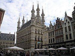
 Leuven Town Hall | |
| Coordinates: 50°53′N 4°42′E / 50.883°N 4.700°E | |
| Country | |
| Community | Flemish Community |
| Region | Flemish Region |
| Province | Flemish Brabant |
| Arrondissement | Leuven |
| Government | |
| • Mayor | Louis Tobback (SP.A) |
| • Governing party/ies | SP.A-Spirit, CD&V-N-VA |
| Area | |
• Total | 57.51 km2 (22.20 sq mi) |
| Postal codes | 3000, 3001, 3010, 3012, 3018 |
| NIS code | 24062 |
| Area codes | 016 |
| Website | www |
{{Infobox Belgium municipality
| name           = Leuven
| namefr         = Louvain
| type           = city
| picture        = Leuven.jpg
| picture-legend = Leuven Town Hall
| map            = Leuven Flemish-Brabant Belgium Map.svg
| map-legend     = Location of Leuven in Flemish Brabant
| arms           = Wapen van Leuven.svg
| flag           = Flag of Leuven.svg
| arrondissement = [[Leuven Arrondissement|Leuven]]
| nis            = 24062
| mayor          = [[Louis Tobback]] ([[SP.A]])
| majority       = [[SP.A]]-[[Spirit (political party)|Spirit]], [[CD&V]]-[[N-VA]]
| postal-codes   = 3000, 3001, 3010, 3012, 3018
| telephone-area = 016
| web            = {{URL|https://www.leuven.be/}}
| coordinates    = {{Coord|50|53|N|4|42|E}}
}}
References
Useful templates
[edit]- Regions :
-
 Brussels-Capital Region {{BE-BRU}}
 Flanders use {{BE-VLG}}
 Wallonia {{BE-WAL}}
- Communities :
-
 Flemish Community {{BE-NL}}
 French Community {{BE-FR}}
 German-speaking Community of Belgium {{BE-DE}}
- Provinces :
-
 Antwerp {{BE-VAN}}
 Flemish Brabant {{BE-VBR}}
 Walloon Brabant {{BE-WBR}}
 East Flanders {{BE-VOV}}
 West Flanders {{BE-VWV}}
 Hainaut {{BE-WHT}}
 Liège {{BE-WLG}}
 Limburg {{BE-WLI}}
 Luxembourg {{BE-WLX}}
 Namur {{BE-WNA}}
Microformat
[edit]The HTML markup produced by this template includes an hCard microformat, which makes the place-name and location parsable by computers, either acting automatically to catalogue articles across Wikipedia, or via a browser tool operated by a person, to (for example) add the subject to an address book. Within the hCard is a Geo microformat, which additionally makes the coordinates (latitude & longitude) parsable, so that they can be, say, looked up on a map, or downloaded to a GPS unit. For more information about the use of microformats on Wikipedia, please see the microformat project.
Sub-templates
[edit]If the place or venue has "established", "founded", "opened" or similar dates, use {{start date}} for the earliest of those dates unless the date is before 1583 CE.
If it has a URL, use {{URL}}.
Please do not remove instances of these sub-templates.
Classes
[edit]hCard uses HTML classes including:
- adr
- agent
- category
- county-name
- extended-address
- fn
- label
- locality
- nickname
- note
- org
- region
- street-address
- uid
- url
- vcard
Geo is produced by calling {{coord}}, and uses HTML classes:
- geo
- latitude
- longitude
Please do not rename or remove these classes nor collapse nested elements which use them.
Precision
[edit]When giving coordinates, please use an appropriate level of precision. Do not use {{coord}}'s |name= parameter.


