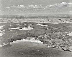
Tākou Bay
Tākou Bay | |
|---|---|
 Tākou Bay in 1973 | |
 | |
| Country | New Zealand |
| Region | Northland Region |
| District | Far North District |
| Ward | Bay of Islands-Whangaroa |
| Community | Bay of Islands-Whangaroa |
| Subdivision | Whangaroa |
| Electorates | |
| Government | |
| • Territorial Authority | Far North District Council |
| • Regional council | Northland Regional Council |
| • Mayor of Far North | Moko Tepania |
| • Northland MP | Grant McCallum |
| • Te Tai Tokerau MP | Mariameno Kapa-Kingi |
| Area | |
• Total | 12.60 km2 (4.86 sq mi) |
| Population (2023 Census)[2] | |
• Total | 132 |
| • Density | 10/km2 (27/sq mi) |
| Postcode | 0295 |
Tākou Bay is a bay and rural community in the Far North District and Northland Region of New Zealand's North Island, beside the Tākou River.[3] Tākou Bay is an official name, gazetted on 16 July 2020.[4]
The local Tākou Marae is a meeting place for the Ngāpuhi hapū of Ngāti Tautahi, Ngāti Tūpango and Ngāti Whakaeke, and the Ngāpuhi and Ngāpuhi / Ngāti Kahu ki Whaingaroa hapū of Ngāti Rēhia.[5] It includes Te Whetū Marama meeting house.[6] The Mātaatua canoe ended its journey in Tākou Bay.[7] Piakoa burial caves in the cliffs above the bay are wāhi tapu on the New Zealand Heritage List.[8] In 2019 Māori Development Minister, Nanaia Mahuta, announced up to $2.3m investment with Te Rūnanga o Whaingaroa in housing at Tākou Bay for repairs and affordable homes.[9]
Demographics
[edit]Tākou Bay is in an SA1 statistical area which covers 12.60 km2 (4.86 sq mi)[1] and includes the area south of the Takou River and northwest of State Highway 10. The SA1 area is part of the larger Rangitane-Purerua statistical area.[1]
| Year | Pop. | ±% p.a. |
|---|---|---|
| 2013 | 111 | — |
| 2018 | 138 | +4.45% |
| 2023 | 132 | −0.89% |
| Source: [2] | ||
The SA1 statistical area had a population of 132 in the 2023 New Zealand census, a decrease of 6 people (−4.3%) since the 2018 census, and an increase of 21 people (18.9%) since the 2013 census. There were 72 males and 60 females in 45 dwellings.[10] The median age was 48.3 years (compared with 38.1 years nationally). There were 12 people (9.1%) aged under 15 years, 24 (18.2%) aged 15 to 29, 66 (50.0%) aged 30 to 64, and 27 (20.5%) aged 65 or older.[2]
People could identify as more than one ethnicity. The results were 84.1% European (Pākehā), 22.7% Māori, and 2.3% Pasifika. English was spoken by 100.0%, Māori language by 4.5%, and other languages by 9.1%. The percentage of people born overseas was 29.5, compared with 28.8% nationally.
Religious affiliations were 34.1% Christian, 2.3% Māori religious beliefs, and 2.3% New Age. People who answered that they had no religion were 54.5%, and 4.5% of people did not answer the census question.
Of those at least 15 years old, 15 (12.5%) people had a bachelor's or higher degree, 60 (50.0%) had a post-high school certificate or diploma, and 33 (27.5%) people exclusively held high school qualifications. The median income was $30,200, compared with $41,500 nationally. 6 people (5.0%) earned over $100,000 compared to 12.1% nationally. The employment status of those at least 15 was that 54 (45.0%) people were employed full-time and 18 (15.0%) were part-time.[2]
References
[edit]- ^ a b c "ArcGIS Web Application". statsnz.maps.arcgis.com. Retrieved 28 November 2024.
- ^ a b c d "Totals by topic for individuals, (RC, TALB, UR, SA3, SA2, Ward, Health), 2013, 2018, and 2023 Censuses". Stats NZ – Tatauranga Aotearoa – Aotearoa Data Explorer. 7000135. Retrieved 3 October 2024.
- ^ Hariss, Gavin. "Takou Bay, Northland". topomap.co.nz. NZ Topo Map.
- ^ "Place name detail: Tākou Bay". New Zealand Gazetteer. New Zealand Geographic Board. Retrieved 15 July 2023.
- ^ "Te Kāhui Māngai directory". tkm.govt.nz. Te Puni Kōkiri.
- ^ "Māori Maps". maorimaps.com. Te Potiki National Trust.
- ^ Rāwiri Taonui (8 February 2005). "Rāwiri Taonui, 'Canoe traditions - Canoes of the northern tide'". Te Ara - the Encyclopedia of New Zealand. Retrieved 15 July 2023.
- ^ "Two Northland sites of significance to Māori listed". Waatea News: Māori Radio Station. 8 April 2021. Retrieved 15 July 2023.
- ^ "Minister congratulates Te Rūnanga O Whaingaroa on initiative". www.scoop.co.nz. 4 February 2019. Retrieved 15 July 2023.
- ^ "Totals by topic for dwellings, (RC, TALB, UR, SA3, SA2, Ward, Health), 2013, 2018, and 2023 Censuses". Stats NZ – Tatauranga Aotearoa – Aotearoa Data Explorer. Retrieved 3 October 2024.
